
What to Know
- Expect sunny, chilly and dry weather through Thursday ahead of our next storm system
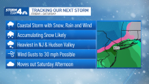
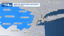
- Rain and snow move in by Friday's evening commute; impacts and accumulations look minor for the NYC area right now but north and west suburbs could see up to 5 inches -- or more
- We're tracking the potential for another storm early next week that could bring yet another round of wind and rain or accumulating snow to the tri-state area Monday night into Tuesday
Want more snow? OK, we're working on it.
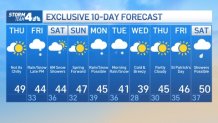
Expect sunny, chilly and dry weather through Thursday, with temps in the high 40s and mainly sunny skies, ahead of our next potential snowmaker. That coastal system approaches Friday afternoon, bringing a mix of rain and snow -- or both -- to the New York City area in time for the evening commute. The storm lingers into Saturday afternoon.
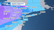
At this point, it looks like spots north and west of New York City have the best chance for accumulating snow. The high-end range for snow potential is in the 5-inch range, and that looks to be in the far northern and western suburbs.
The heaviest snow should fall in New Jersey and the Hudson Valley, where new models early Thursday were showing projected totals creep up a bit. Much could change over the next 24 hours, of course, so stay with Storm Team 4 for all the latest need-to-know updates. Check the latest National Weather Service alerts here.
Get Tri-state area news delivered to your inbox. Sign up for NBC New York's News Headlines newsletter.
Impacts and accumulations currently look minor for NYC and along the coast, though some light accumulation is possible in the five boroughs before the storm exits later Saturday. We'd likely get an inch or less.
Long Island has even lesser chances for snow accumulation, based on the current models. If the storm tracks far enough offshore, though, it could be a total dud.
What's Next? 10-Day NYC Weather Forecast
Once the next system moves out, we've got a good-looking Sunday, with temperatures in the mid-to-high 40s and mostly sunny skies. We spring forward, too, on Sunday, March 12, so don't forget to change the clocks! (More on Daylight Saving Time here.)
We get another chance for rain and snow Monday night into Tuesday. As has been the case with most of the recent storms, this one will also have a rain-snow line scenario, with a better chance of snow to the north and west of the city.
Regardless of where the snow and rain go, the storm has cold air behind it, meaning we'll finish next week with below-average temperatures. Some may get stuck in the 30s -- and we're looking at strong winds, too. St. Patrick's Day looks to be a bit chillier than usual, with temperatures in the mid-40s, but skies look to stay clear at this point.
Sign up for our newsletters here.
More News


Track any approaching precipitation using our interactive radar below.