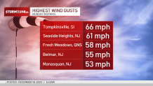
Flooding rains battered the New York area overnight and into Monday, trapping dozens in multiple cities, as 60 mph winds uprooted trees and knocked out power to hundreds of thousands across the region.
More than five inches of rain fell in parts of New Jersey and northeastern Pennsylvania by mid-morning. Some areas, like Long Valley, New Jersey, saw closer to 6 inches. Other parts of the tri-state got more than four inches, according to the National Weather Service. Wind gusts reached nearly 70 mph in parts of the NYC area, including Staten Island and Stamford, CT.
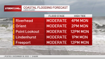
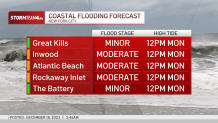
The 12-hour deluge combined with the fierce winds crippled travel, and while the brunt of the system had moved out by 8 a.m., Monday's high tide was expected to have possibly dramatic impacts along the coast.
High Tide
Moderate coastal flooding looks to be widespread during Monday afternoon's high tide. It could be major in isolated spots, with inundation 3 feet above ground possible. Surge flooding is likely in tidally affected rivers as well.
Get Tri-state area news delivered to your inbox.> Sign up for NBC New York's News Headlines newsletter.
Weather Stories
Minor to moderate flooding of vulnerable rivers across northeast New Jersey, the Lower Hudson Valley and southwest Connecticut is possible. Some rivers could hit a major flooding stage if the rainfall total hits the high-end expectation. Expect residual street and river flooding through midday Monday.
Some rivers, including the Passaic and Saddle rivers, and creeks will keep rising, not cresting until Tuesday.
Heavy rain and high tides caused flooding along the Jersey Shore earlier Monday, leading authorities to block off roads near Barnegat Bay in Bay Head and Mantoloking. The flooding was made worse by leaf piles that residents had put out for collection but were blocking water from reaching drains.
Power was knocked out for more than 700,000 customers in an area stretching from Virginia north through New England at the height of the storm, including over 278,000 in Massachusetts and 263,000 in Maine, according to poweroutage.us. By 3:30 p.m. Monday, there were still nearly 100,000 customers without power across the tri-state.
Nearly 80 flights were canceled and more than 90 were delayed at New York-area airports, according to FlightAware. Many school districts canceled or delayed classes because of the conditions. Commuter rail systems were reporting delays.
In New York City, high winds prompted the temporary closure of the Verrazzano Bridge. It reopened later Monday morning, but with a ban on tractor-trailers and other large vehicles. State government officials urged people to avoid traveling and driving on flooded roads.
Guilford, Connecticut, police said a tree fell on a police cruiser, but the officer was not hurt. In Queens, a tree fell on a couple's car near 77th Street and Grand Central Parkway. The duo escaped unscathed and were seen hugging one another on the pavement as firefighters worked to clear the roadway.
New York City says it received at least 90 reports of downed trees across the five boroughs. No serious injuries were immediately reported.
The city of Paterson, New Jersey, declared a state of emergency as a result of the storm, in response to the severe storms and resultant flooding.
A travel advisory remains in effect for New York City Monday. High wind warnings and other weather alerts also are active for parts of the tri-state area through midday. See those here.
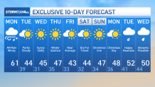
Gusts up to 30 mph are still possible into early Monday afternoon, and it stays breezy overnight. With temperatures dropping into the 30s Monday night, wind chills will be in the 20s come Tuesday morning.
The forecast looks dry for the rest of this week and into the holiday weekend (sorry, no white Christmas), though the risk for storms returns by the middle of next week. Stay with Storm Team 4 for all the latest details.

Check out our 10-day forecast below. Get more need-to-know weather information here.
