
What to Know
- Strong storms could fire up again Wednesday after daytime feels-like temps topped 100 degrees; excessive heat warnings and watches and heat advisories are in effect
- Tuesday's storms did not do anything in terms of providing relief from the heat and humidity; that does not come until late Wednesday with the passage of a cold front
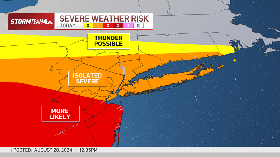
- A severe thunderstorm watch has been issued for the entire New York City area through Wednesday evening, with radar indicating damaging winds and intensifying, heavy rain for the region over the next few hours
A severe thunderstorm watch has been issued for the entire New York City area through Wednesday evening, with radar indicating damaging winds and intensifying, heavy rain for the region over the next few hours.
As early as Wednesday afternoon, showers and storms started to push into the Hudson Valley. Severe thunderstorm warnings were issued throughout the evening as lines of powerful storms made their way from west to east, bringing heavy rains and intense winds for hours, along with plenty of thunder and lightning.
The storms grew more widespread as the evening worse on.

Do not be surprised if you get caught in a downpour during the evening. These storms will bring some pockets of heavy rain, which could contribute to localized minor flooding. Exercise extra caution if your commute takes you over low-lying or flood-prone roadways.
Get Tri-state area news delivered to your inbox. Sign up for NBC New York's News Headlines newsletter.
There were reports of flooding, mostly in Bergen and Hudson counties of New Jersey, later in the evening. Meadowlands Parkway was closed near Hudson Regional Hospital, while there were flood rescues reported on West Pleasant Street and Green Street in Hackensack.
Check the latest weather alerts for your neighborhood here.

Beyond localized flooding, the greatest concern with these severe storms will be damaging winds, producing gusts up to 60mph. Gusts of this strength can blow limbs off trees and knock down power lines.
Weather Stories
There were several reports of trees and power lines downed throughout the Hudson Valley. Three people at High Tor State Park in Rockland County told New York State Park Police that they had felt the effects of an indirect lightning strike on two trees nearby around 5 p.m. All three were conscious and alert, state park police said.
The heavy rains led to delayed service on Metro-North Wednesday evening, with 15-minute delays on the Harlem Line and delays of up to a half hour on the Hudson Line.

A few showers could linger into early Thursday morning, but most of the rain will come through Wednesday night.
In need of relief
Nearly the entire tri-state is under heat alerts through 8 p.m. Wednesday. North Jersey, the Hudson Valley, Connecticut, Long Island, and the city can anticipate another day with feels-like temperatures up to 104, while Central and South Jersey could feel as hot as 105.
But no matter where you are, the heat is sweltering.


This level of heat, especially when it persists for multiple days, takes a physical toll. Avoid strenuous activity, limit time spent outdoors, and stay hydrated. Check in on kids, pets, and the elderly. The heat can be especially difficult for them.

The passage of Wednesday night’s cold front will do wonders for the heat and humidity. Temperatures
will be back near July averages, and humidity will return to a tolerable level.
We’re in for a gorgeous end to the week.


Track any approaching storms using our interactive radar below.