
Latest Forecast From Storm Team 4
What to Know
- It stays dreary outside through the Friday morning commute; we'll dry out by midday, but clouds will linger into Saturday
- Sunday brings wind and rain back which may turn to snow Sunday night into Monday morning for areas far north and west of the city; most of coastal New Jersey, New York and Connecticut will just see rain
- Once that system moves out it feels more springlike, with temps staying in the 40s; February begins with near-normal temps
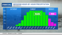
Snow lovers may be disappointed with the weather this weekend. A storm that was looking like it could start as rain before turning to snow now appears it will bring rain for most of the immediate NYC metro area.
The change in the forecast is the result of temperatures trending warming for early next week, which will lead to rain instead of snow for city residents.
Watch NBC 4 free wherever you are
The next storm moves in pretty quickly, following a dreary few days. Showers are expected by early Sunday with rain and gusty winds expected to pick up into the evening. Some transition to snow Sunday night is likely in the Hudson Valley and northern Connecticut, while that warm airs keeps rain around for everyone else.
Rain or snow this weekend?
Get Tri-state area news delivered to your inbox with NBC New York's News Headlines newsletter.


Local


New York City recorded its first one-inch snowfall at Central Park in nearly two full years earlier this month. The New York City area is far below its normal snowfall by this time of year.
Temperatures fall back into the 30s Monday and are expected to stay there through at least the middle of next week.
Check out the 10-day forecast outlook and track any approaching systems using our interactive radar below.
