What to Know
- A powerful winter storm descended on the tri-state area overnight and made for treacherous travel early Tuesday; the snow tapered off by early afternoon
- Parts of the New York area saw nearly a foot of snow, while Central Park recorded barely more than an inch
- Hundreds of flights were canceled or delayed across the region and New York City schools switched to remote learning for the day
A powerful winter storm swooped into the New York area overnight, dumping nearly a foot of snow on spots throughout its hours-long siege Tuesday.
New York City plows were out for the first time in two years, though Central Park (1.2 inches) and LaGuardia (0.6 inches), for example, didn't record much accumulation. During the heaviest snowfall, though, even midtown Manhattan looked like a whiteout. The snow tapered off for most of the region by early afternoon.
Tuesday's storm was the biggest snowfall in Central Park in 24 months. The last time we got this much snow was Jan. 28-29, 2022 when New York City saw 8.5".
Orange County in New York appears to be hardest-hit, with nearly a half-dozen locales recording almost a foot of snow before noon. Snowfall was more moderate in New Jersey, where just 2 inches fell in Hoboken. A widespread 3 to 5 inches of snow were noted elsewhere across the Garden State. Check snow totals here.
Get Tri-state area news delivered to your inbox. Sign up for NBC New York's News Headlines newsletter.

A winter storm warning for New York City and most of the rest of the tri-state area is in effect through much of the day Tuesday. Check weather alerts here.
News
New York City schools announced they would go fully remote Tuesday in anticipation of the storm, and Mayor Eric Adams urged everyone who could to stay home. There were more than a few headaches when students awoke to sign onto their accounts Tuesday morning, but the Department of Education stressed it was working on improvements. Check school closings and delays.
New York City suspended alternate side parking regulations for Tuesday. Parking meters are in effect.
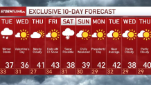
What can we expect for Valentine's Day?
Once the storm moves through Tuesday, we can expect cool, but seasonable temperatures for the rest of the week.
Valentine's Day is expected to be partly sunny with highs in the 30s and lows in the 20s.
There's a chance of snow showers next Saturday, but it's too early to say anything definitive at this point.

See the latest forecast in your area anytime here.


