January 2025 is over-delivering when it comes to wintry temperatures. While the coming week won’t bring us the coldest air of the season, it will be the longest cold snap so far. We’re looking ahead to temperatures hovering at or below freezing for at least the next week and a half.
And with freezing temperatures comes the chance for accumulating snow, two chances in fact.

For the Tri-State Area, there are a couple of opportunities for measurable snow in the days ahead. And it looks like Central and South Jersey will be the place to be for the biggest accumulation.
Get Tri-state area news delivered to your inbox.> Sign up for NBC New York's News Headlines newsletter.

Chance for Friday snow in New Jersey
The first round comes Friday afternoon and evening. A weak clipper passes south of the city will drop between 1 and 3 inches of snow in South Jersey. Ocean County is best positioned for accumulating snow, while the New York City Metro Area will get flurries at best.

The timing of Friday’s snow could be tricky even for those getting a dusting. Light snow can still lead to slick roads and reduced visibility, so if you’re in Central and South Jersey, drive safely and slowly if you’re out on the roads Friday afternoon and evening.

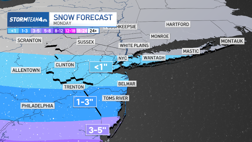
Chance for measurable snow in New York City on Monday
Our second storm system, hammering the Pacific Coast on Friday, will race across the middle of the country and pass just south of New York City on Monday. It will produce a broad swath of snow and ice that could hamper travel for the last travelers heading home after the holidays. Winter Storm Watches are already in place from Kansas to Ohio.

For the Tri-State Area, this storm will have a bigger impact than Friday’s storm.
Weather Stories
In New York City, temperatures will certainly be cold enough for snow – the big question is how much moisture will be available to generate snow. Most of the moisture will be south of the city and that’s where the highest accumulations will be – once again through Central and South Jersey.
However, with the storm still three days away, the track of the system could shift from the current forecast. That would, in turn, shift the swath of heaviest snow either north or south.
Stay tuned to StormTeam 4 through the weekend for updates to the forecast and the snow totals expected throughout the Tri-State Area. If you don’t already have it, now is a good time to download the free NBC New York App to get the most up-to-date forecast and live radar to track the snow as it moves through.

The snow will arrive around mid-morning on Monday. Most early morning commuters will have little to no trouble on the roads. But if you’re heading out later in the morning or any time through the evening, roads will look very different. Exercise caution and budget extra time to get to your destination, especially if your drive takes you on local, untreated roads.

Neither system is a blockbuster worth cancelling school over, but there is enough snow to give parts of our area, especially New Jersey, a wintry coating of white. And thanks to our temperatures staying near freezing, any snow that we do get will be sticking around for a while.

This is scenic, even shovel-able for some, snow but it won’t be especially impactful. Anyone hoping for a big winter storm is going to have to wait a little longer. The cold is here, but we need a big storm system to line up with these freezing temperatures in order to rack up the hefty snow totals.
It only takes one well-timed, well-placed storm to get some serious snowfall in Central Park.


