This livestream has ended.
Nicole strengthened to a Category 1 hurricane Wednesday evening as it was over the Bahamas, and is expected to remain at that strength before hitting Florida’s east coast early Thursday morning.
The National Hurricane Center predicted a particularly wobbly forward movement for Nicole as it approaches Florida before crossing into the northwest Gulf of Mexico. As of 1 a.m. Thursday, the storm was about 30 miles east-southeast of Fort Pierce with maximum sustained winds of 75 mph and higher gusts — a continued increase from days prior.
The storm became a hurricane hours before its expected landfall on the east coast of Florida early Thursday morning. Nicole should weaken while moving across Florida and the southeastern U.S. Thursday through Friday, and should be a post-tropical cyclone by Friday afternoon.
NHC described the system as a large tropical storm, with hurricane-force winds extending outward up to 25 miles from the center, and tropical storm-force winds extending outward up to 485 miles. Tornadoes are possible in parts across eastern Florida Wednesday into Thursday.
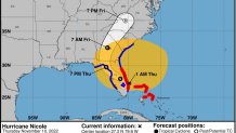
On the current track, the center of Nicole will move ashore in Florida before sunrise Thursday, NHC says. Nicole's center is then expected to move across central and northern Florida into southern Georgia throughout the day and into the evening, then into the Carolinas on Friday. See potential local impacts for the New York area here.
Get Tri-state area news delivered to your inbox. Sign up for NBC New York's News Headlines newsletter.

A hurricane warning has been issued for parts of Florida's east coast, from Boca Raton to the Flagler/Volusia County line. One is also in effect for the northwestern Bahamas, including the Abacos, Berry Islands and Grand Bahama Island.
A tropical storm warning is in effect for Bimini in the northwestern Bahamas and Florida's Hallandale Beach to Boca Raton. The warning also covers the Flagler/Volusia County line in Florida to the South Santee River in South Carolina, Lake Okeechobee and spots north of Bonita Beach to Indian Pass in Florida, NHC said in its latest update.
Tropical storm conditions are occurring along portions of the east coast of Florida and will spread north within the warning area through Georgia and South Carolina Wednesday, NHC says. Hurricane conditions are expected within the hurricane warning area in Florida Wednesday night or Thursday morning.
A storm surge warning has been issued for most of Florida's eastern seaboard, stretching from North Palm Beach up to the Altamaha Sound in Georgia. On the Gulf Coast side of the state, a storm surge warning is in place from the Anclote River to the Ochlockonee River. Parts of Florida could see 5-foot storm surges, which could be deadly. People are advised to take caution.
Meanwhile, a hurricane watch is in effect for Lake Okeechobee. Storm surge and tropical storm watches are also in effect. See the latest advisory here.
The track can be deceiving, though, NHC warned.
“Do not focus on the exact track of Nicole since it is expected to be a large storm with hazards extending well to the north of the center, and outside of the cone, and affect much of the Florida peninsula and portions of the southeast U.S.,” its latest advisory said.
Storm surge could raise water levels by as much as 5 feet above normal tide levels in the warning areas, NHC says. The deepest water will occur along the immediate coast near and to the north of the landfall location, where the surge will be accompanied by large and destructive waves. Parts of Florida could see up to 8 inches of rainfall.
More Weather
Florida Gov. Ron DeSantis declared a state of emergency for 34 counties in the potential path of the storm, out of an abundance of caution.
“While this storm does not, at this time, appear that it will become much stronger, I urge all Floridians to be prepared and to listen to announcements from local emergency management officials,” DeSantis said in a statement.
“While this storm does not, at this time, appear that it will become much stronger, I urge all Floridians to be prepared and to listen to announcements from local emergency management officials,”
Large parts of the state have yet to recover from destructive Hurricane Ian, which slammed into southwestern Florida on Sept. 28 as a strong Category 4 hurricane and dumped massive amounts of rain, causing flooding across central Florida.
The Atlantic hurricane season began on June 1 and ends on Nov. 30.


