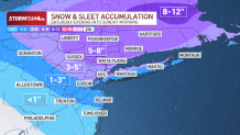
Up to 8 inches of snow is expected in some parts of the tri-state, including the Hudson Valley and Connecticut.
Exclusive, interactive StormTracker 4 Radar will allow you to keep an eye on the snow timing, direction and any switchover to sleet or rain in your community.
Watch NBC 4 free wherever you are
New York City snowfall forecast: How much snow could we see?
Hour-by-hour winter storm forecast: When will the snow start and end?
Get Tri-state area news delivered to your inbox with NBC New York's News Headlines newsletter.
The forecast range for NYC of 2-5 inches is about right, but we could see a wide range of 1 inch in Staten Island and 5 inches in the north Bronx -- quite a difference across the five boroughs.
The heaviest totals are expected north and east of NYC, 5-8 inches, where the winter storm warning is set.
Weather Stories

Snowfall rates could approach an inch an hour before midnight.
By mid-Sunday morning, the storm is essentially over with only a few flurries still lingering.