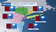
Snow, sleet and icy rain pelted parts of the tri-state area early Thursday, dusting cars anew and glazing streets as dozens of school districts across the region adjusted schedules to accommodate the weather.
A winter weather advisory is in effect for the entire tri-state area, except for eastern Suffolk County on Long Island and immediately along the coast of the Jersey Shore. Check the latest weather alerts for your neighborhood here.

Watch NBC 4 free wherever you are
The system arrived in the New York City metro area in the pre-dawn hours Thursday. It started all snow and though not heavy, it is still enough to reduce visibility and make for some slippery conditions for people hitting the roads. Take it easy and give yourself plenty of time to get to your destination, especially if you’re traveling on untreated roads.
As the morning goes on, warmer air moves into the region and precipitation switches from snow to sleet, freezing rain and rain, though the exact type of precipitation will differ based on timing and location.
Get Tri-state area news delivered to your inbox with NBC New York's News Headlines newsletter.
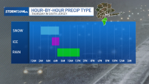
For South Jersey, a brief period of sleet and freezing rain mixes in with the snow before switching to all rain by sunrise. If you are out on the roads early, you’ll primarily have the thin dusting of snow to contend with. But if your commute puts you on the roads closer to rush hour, the relatively warmer temperatures in conjunction with the rain will result in a good amount of slush.
Into north and central Jersey, there is a better chance of seeing some light icing during peak commute hours, especially on untreated sidewalks, bridges, and roadways. This will come on top of the initial pre-dawn snowfall.

News


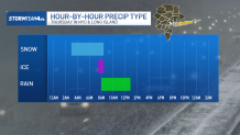
Similar to South Jersey, NYC and Long Island have a short changeover to sleet before switching to all rain. Timing however is a little bit later because the warmer air is moving into the region from the south, meaning the city will hold onto freezing temperatures a little longer, allowing snow to briefly accumulate, especially further west.
By the late morning commute, it's largely all rain — which will, again, result in more slush than snow as the system moves out.
The icing amounts won’t be catastrophic; in places where ice does accumulate, it’ll add up to less than a tenth of an inch area-wide, with most not getting more than a thin glaze.
But even a light amount of ice can make travel particularly problematic. If a surface looks wet, there’s a good chance it’s actually ice.

The Hudson Valley will see majority snow through Thursday morning. Brief pockets of sleet and freezing rain are possible as the system begins to exit by late morning, but there will be little to no changeover to rain.
When all is said and done, around 1 to 2 inches will add up across much of New Jersey and into the Hudson Valley. Even parts of NYC and western Long Island could pick up close to an inch. Slightly higher totals in the 2-3 inch range will be confined to the higher elevations.


While we are not expecting any monster snow or ice totals anywhere from this system, it is the timing of it that will make it so impactful.
For those who can work from home, it will be a great day to do so. For the kids, it’s unlikely you’ll be getting a snow day, but a delayed opening is quite possible.
By the evening commute, showers will be long gone and much of the AM snow will have started to melt.
This will be a much quieter commute compared to the morning drive, but still anticipate some slick or icy patches on the roads, especially with some of the snowmelt refreezing as temps further north and west dip back below freezing. Stay mindful of your surroundings if you need to be out.
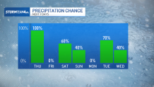
Beyond Thursday, we get a quick breather on Friday before our next sloppy wintry system moves through this weekend. That’ll be followed closely by another rain/snow/ice chance early the following week. We have busy and messy week and a half ahead of us; Thursday is just the start of it.