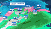
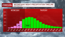
Quick on the heels of the overnight snow, another low ramps up Wednesday night into Thursday.
The second system headed to the tri-state this week will not be as forgiving as its predecessor in terms of timing and precipitation type. The timing on this one will drag on into the morning commute Thursday, which may become a soggy mess.
Winter weather advisories are in place for the Hudson Valley, Connecticut and northwestern New Jersey for light snow and ice accumulations. For the areas under an advisory, like the Catskills and the Poconos, this system will largely bring snow and sleet, with a transition to rain as the storm exits.
Watch NBC 4 free wherever you are
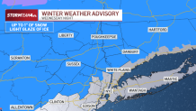
For lower elevations and coastal areas, including the New York City area, it will be a mix of snow and ice that turns over to mainly rain. The sanitation department issued a Winter Operations Advisory until 6 a.m. Thursday, which is a "lower level" snow-fighting notification.
Get Tri-state area news delivered to your inbox with NBC New York's News Headlines newsletter.
As rain takes over with the rising temperatures, it will make for a soggy, not slushy, Thursday morning commute in and around NYC.
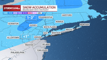
Snowfall totals area-wide will be unimpressive. Snow accumulations in the mountains will be up to 2 inches in some spots, while most other areas will pick up less than an inch. And even then, those meager amounts will melt in the rain that follows the snow.
Weather Stories

Ice accretion up to a tenth of an inch is possible as well, though most will be contending with a thin glaze. Still, that is more than enough to make for some slick spots Thursday morning; watch your step as you head out the door.
Check the latest weather alerts for your neighborhood here.
Regardless of precipitation type, this is another system that will have largely moved on prior to the start of the morning commute. Most of us can look forward to nothing more than damp roads, though some light slush or an icy glaze is possible further north in the Hudson Valley.
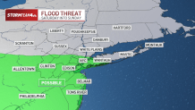
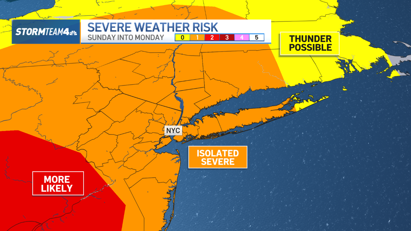
The third system to move through the tri-state area will impact the weekend, arriving Saturday and continuing through the day on Sunday.
Temperatures this weekend will start below freezing in the city, so expect all snow at the beginning. Into the evening, temperatures will quickly warm, changing the wintry precipitation from snow to rain. That means less treacherous driving conditions, but your weekend plans might be impacted by the less-than-stellar weather.
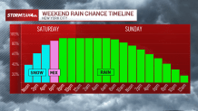
The warming will be slower into the Hudson Valley, so the changeover to rain there could happen as late as Sunday morning.
If your plans are weather-dependent this weekend, it would be a good idea to get them done early Saturday, before the snow sets in. Once the snow starts, the rest of the weekend will be messy.

The duration and rainfall rates of this system will make for a decent soaking. When all is said and done, area-wide rain totals will be between 1 and 2 inches.
It’s much-needed rain, as we are still in a drought. But all that rain in conjunction with the melting snow cover, could lead to minor flooding in nearly all of New Jersey, parts of the city and onto Long Island.