After meager rainfall Sunday night, we’re back to extreme fire danger in the tri-state area Tuesday.
A red flag warning is in place for the New York City metro area, the Hudson Valley, Catskills, Connecticut and Long Island. Elsewhere, the fire danger remains very high. Check the latest weather alerts for your neighborhood.

Unfortunately, there is no appreciable rain in sight in the coming weeks to alleviate our ongoing drought.
Get Tri-state area news delivered to your inbox.> Sign up for NBC New York's News Headlines newsletter.

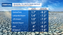
Current rainfall deficits this fall stand at nearly 8 inches in most areas. It’s going to take a lot more rain than the one- or two-tenths of an inch that most places Sunday night to get us back to normal.

Inevitably, with worsening drought comes wildfires. Tuesday, and possibly later in the week, we’ll have some combination of low relative humidity and gusty wind. It’s all a recipe for fires to start easily and spreading quickly.
Note that the wind will be from the northwest, so inland fires in northern New Jersey will blow smoke over the NYC metro area and Jersey Shore. Don’t be surprised if you smell smoke from time to time this week as current fires burn and new ones flare up.


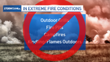
To help prevent fires from starting, do not burn anything outside. Safely dispose of cigarette butts. Don’t park your car on land with dry brush. Don’t use tools outdoors that can generate sparks.
It doesn’t take much in our current environment to start a fire.


