Intense thunderstorms started slamming parts of the New York City area Tuesday afternoon, bringing heavy downpours and the threat of flooding to impacted areas throughout the evening.
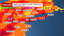
From this system alone, rainfall rates reached and even exceeded or exceed two inches or more per hour in localized areas, with 2 to 4 inches of total rainfall not uncommon.
Flash flood warnings were issued across the tri-state throughout Tuesday evening, and were still in effect for parts of New Jersey until the overnight hours into Wednesday.
The Bronx and Westchester were among the areas hardest hit by the rain. Storm Team 4's exclusive StormTracker radar showed an estimated of 3-5" of rain had fallen in those areas amid multiple flash flood reports.

Get Tri-state area news delivered to your inbox. Sign up for NBC New York's News Headlines newsletter.
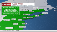
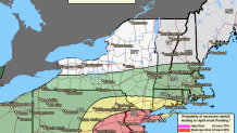
A severe thunderstorm watch was in effect for nearly all of New Jersey, along with Orange and Rockland counties in New York, through late evening. A flood watch was in effect for the entire tri-state area into early Wednesday ahead of the cold front that will knock down temperatures after dumping a sizeable amount of rainfall. Check the latest severe weather alerts for your neighborhood here.
Local

LaGuardia, JFK and Newark airports all had flight delays Tuesday evening, with inbound flights to JFK and LaGuardia being held from their point of origin for more than four hours on average. Passengers and anyone making an airport pickup or drop off were asked to check the flight status with the airline ahead of time.
Driving was just as treacherous as driving, with flooded streets becoming impassable. Six people had to be rescued from the Cross Bronx Expressway after their vehicles got stuck in floodwaters, as the highway at some points was submerged in a foot or more of water.
Trees and wires were also reported downed in New Jersey and Long Island amid the storms.
Not everyone will see these heavy storms, but where they do set up there is a heightened flood possibility. There were already reports of flooded streets in New Jersey and New York City by 6 p.m., and one storm cell near the border of the Bronx and Westchester County dropped 2-4 inches of rain on the in just a matter of a couple hours.
In addition to the flood threat, powerful storms will be possible, with the biggest threat being damaging straight-line wind that could snap tree limbs and cause power outages. Isolated hail was also possible.
Areas west of New York City are at greatest risk for severe storms. The most frequent and heaviest storms will continue throughout the evening, with things winding down overnight — though scattered showers will continue into both Wednesday and Thursday.
New York City Mayor Eric Adams cautioned those in the five boroughs not to minimize the threat.
"We have serious rain coming our way starting this afternoon," he posted on X. "Avoid travel if you can."
More impactful weather is again possible Friday into Saturday, as a front approaches the area and may interact with Debby’s remnants. This could once again result in a period of heavy rainfall.
Keep in mind, Debby still needs to make a second landfall in South Carolina and travel across five or six states before approaching, so impacts and timing of the storms are subject to change.
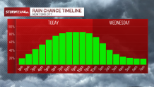
Depending on timing, the NYC area could be contending with a good amount of tropical moisture coming from what's left of Debby by the weekend. Between 2-5 inches of rain is expected to fall across the region over the next seven days, with isolated totals as high as 8 inches.
The good news: Sunday into the start of next week looks lovely.
Track any approaching storms using our interactive radar below.
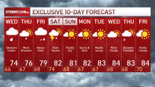
10-day NYC forecast outlook