
Latest Forecast From Storm Team 4
After a relatively quiet week, showers are back this weekend as we ready for St. Patrick's Day.
This weekend won’t be a total washout, far from it. But we're expecting enough rain to make a mess of at least part of Sunday and even the start of Monday.
Saturday is the drier half of the weekend, but it’s not exactly a day everyone will want to spend outside either. The day gets off to a foggy start with clouds hanging around for the rest of the day. There won’t be any measurable rainfall but expect it to feel a little misty outside, with a stray sprinkle possible.
Watch NBC 4 free wherever you are

Sunday stays mostly dry through the first half of the day. This is good news for anyone running the New York City half marathon in the morning. Runners won’t have to worry about dodging puddles.
Get Tri-state area news delivered to your inbox with NBC New York's News Headlines newsletter.
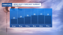
But it still won’t be perfect weather; winds are going to be gusty.
The tri-state will face sustained winds 10-15 mph, with gusts reaching 25-35 mph. Winds this strong may be helpful when they’re coming from behind, but as a headwind, they’ll make the run that much more onerous.

Showers start to move in late Sunday afternoon continuing through the overnight and into Monday morning. This is the same system that is bringing devastating storms to the Midwest on Friday and the Southeast on Saturday. Those regions face the threat of destructive wind gusts, baseball-sized hail, and several strong tornadoes.
Weather Stories
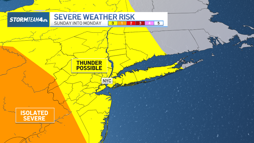

By the time this system makes its way to the tri-state, the greatest severe threat will have passed, but we will still face the chance for isolated severe weather, with the greatest concern being the destructive winds.
Gusts could get up to 60 mph, which is strong enough to knock branches off trees and even tumble power lines. Primary timing for the worst of this will be overnight into early Monday.

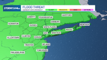
By the morning commute on Monday, showers will still be around, but the greatest storm threat will be over. You should still anticipate some isolated pockets of heavy rain which will make for reduced visibility at times.
This storm doesn't look to bring any massive flood threat but there is a risk for some minor flooding on low-lying roads and other flood-prone areas. If your commute involves a road with a propensity to flood, give yourself a little extra time for the morning drive and have an alternate route planned as a back-up.
Overall, this system will deliver a decent amount of rain across the region. Most of the area will see between a half inch and an inch of rain. But out on Long Island, where showers will linger a little longer into Monday, totals will be in the range of 1-2 inches.
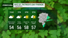
Thankfully, the rain will have cleared New York City before the start of the St. Patrick’s Day Parade on Monday, so parade-goers will not have to worry about bringing the ponchos.
In fact, it won’t take long before sunshine breaks through the clouds. Temperatures will climb into the upper 50s with a healthy breeze from time to time, but it’s nothing that’ll encumber the festivities.
All in all, it should be a pretty nice event; just grab a jacket, sunglasses, and something (or several things) green.