
Heat will continue to build on Wednesday in the New York City area and it won't let up for days — plus it comes with an air quality alert today.
That air quality alert was issued until 11 p.m. Wednesday for NYC, Westchester, Rockland, Orange, Putnam counties in New York; Bergen, Passaic, Hudson, Essex, and Union counties in New Jersey; and Fairfield, New Haven, and Northern Middlesex in Connecticut. The alert is a warning that the air quality may approach a level that is unhealthy for sensitive groups.
Another air quality alert will be in place again Thursday for NYC and the surrounding area, with the AQI forecast to reach levels deemed "Unhealthy for Sensitive Groups."
Heat advisories went into effect for most of the region Tuesday, except for New York City, Long Island and the shoreline of New Jersey and Connecticut (but don't worry, it'll still be plenty hot in those areas too). While it might not quite reach a heat wave for the city, Wednesday did mark the third straight day of at least 90-degree heat for Newark, making it an official heat wave in parts of the tri-state.
Central Park fell just short of 90 degrees (reaching 89), but had a heat index that peaked at 95. Thursday looks more likely for NYC's first 90-degree day of the water. Poughkeepsie hit a record high of 94.
Heat indices are expected over 95 degrees in inland areas for the rest of the week. Temperatures are expected to climb higher along with higher overnight lows, meaning minimal overnight relief is in sight.
Get Tri-state area news and weather forecasts to your inbox. Sign up for NBC New York newsletters.
The heat will continue to build, with the hottest days expected to be Thursday and Friday, as highs reach the mid-90s. Temperatures will go back down a bit over the weekend, but there is no real break expected in the near future.


Weather Stories
The warm, humid weather will be downright dangerous — and not just because of the higher temperatures and humidity, but because of the cumulative effect and the lack of relief overnight. There is a chance some areas in the tri-state could set some record high overnight temperatures.
Parts of New Jersey will face an excessive heat watch on Thursday and Friday when the heat index will climb up to 105. Some school districts in the state let students out early on Wednesday as temperatures began to soar.


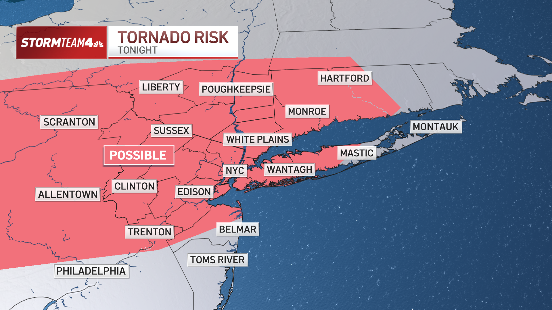
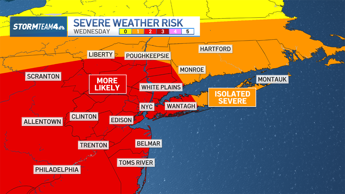
Afternoon and evening storm chances pick up Friday and last through early next week.
Storm chances possible this week
Storm chances pick up Thursday with a possible spotty shower well north of NYC in Sullivan, Ulster, and Dutchess counties.


Friday’s forecast high of 94 degrees would approach the record for the day for Central Park, but likely will fall a few degrees short. The all-time record for the month of June (at Central Park) is 101.
The chance for showers on Friday increases as a cold front moves closer, and the threat will linger Saturday evening through Monday. Rather than helping bring relief for the heat, any storms could actually make it feel more humid outside.
New York Gov. Kathy Hochul is activating the National Guard to help people in the heat. The MTA said heat patrols will be deployed to inspect train tracks to keep service running. In New Jersey, some schools have early dismissal for the rest of the week due to the scorching temperatures.
A tiny bit of the edge from the heat will go away over the weekend, at least on Saturday, though it will remain very warm and muggy across the region. In fact, Sunday may be as rough as Friday in terms of dangerous heat and humidity combination. We see a brief break with temperatures and humidity by Tuesday.
Any sort of relief from the heat will be brief. After the weekend, temperatures will linger in the upper 80s and will once again near 90s by mid-week, so make sure that A/C is running well. Sadly, no long-term relief is in the forecast for June.

Exclusive Storm Team 4 10-Day Forecast
Next week remains hot with chances of thunderstorms.

