nyc weather
Live Blog EndedMar 31, 2025

Severe storms trigger tornado warnings, bring heavy rain, wind, hail to NYC area

Live
 

What to Know

  • Severe storms brought powerful wind gusts, large hail, isolated flooding and even tornado warnings Monday night
  • Some storms started popping up west and northwest of New York City in the late afternoon, producing heavy rain and gusty winds
  • The weather won't did not arrive in the NYC area until after 9 p.m.
  • A tornado warning was issued for Middlesex and Monmouth counties in NJ until 10 p.m.

A line of strong to severe storms hit the tri-state area Monday night. Damaging wind gusts, large hail, isolated flooding and even an isolated tornado were all possible.

As for the timing of the storms, some started popping up west and northwest of New York City in the late afternoon, producing heavy rain and gusty winds.

Fortunately for commuters, the heaviest and most widespread storms didn't move in until after the peak of the evening rush, with the main event pushing in after dinner time. Wind gusts around 60 miles per hour and quarter-sized hail were also possible.

Check the latest weather alerts for your neighborhood here.

MAR 3110:38 PM EDT

Storms move past NYC, hit Long Island as they weaken

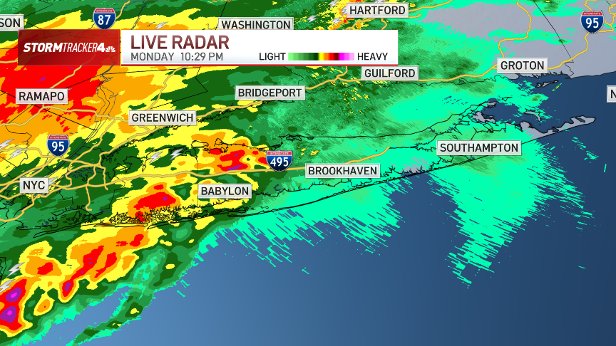
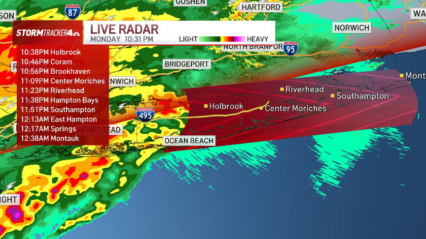
The strongest storms made their way through New York City by 10:30 p.m. or so, and were working east through Long Island.

Those storms weakened as they continued to head east onto the island. Severe weather is not anticipated for the rest of the night, but heavy downpours and lightning will still be common.

MAR 319:50 PM EDT

Tornado warning canceled for Monmouth County, threat dissipates

The tornado warning for Monmouth County has been cancelled early.

The rotation within the storm dissipated and the tornado threat is no longer present. Doppler radar had indicated rotation within a storm north of Freehold moving east at 30 mph.

That said, torrential rain is still coming down from this storm cell, so remain in a secure building until it passes.  Stay safe!

MAR 319:25 PM EDT

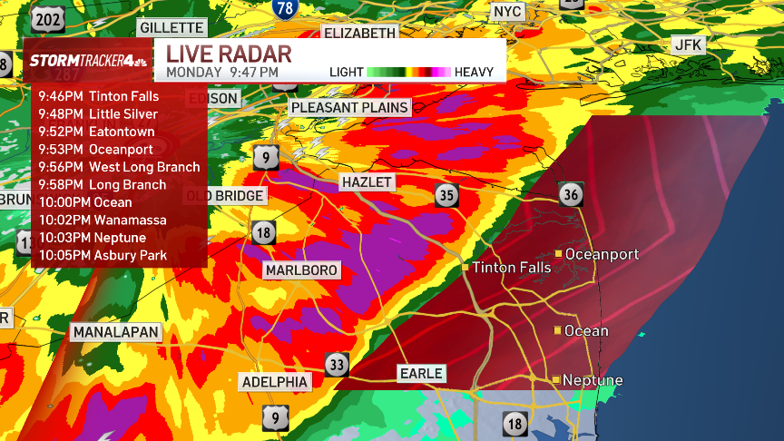
Tornado Warning issued for Middlesex, Monmouth counties in NJ

A tornado warning was issued for Middlesex and Monmouth counties in New Jersey until 10 p.m. Seek shelter immediately.

MAR 318:57 PM EDT

When will storms arrive in NYC?

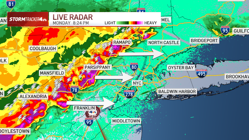
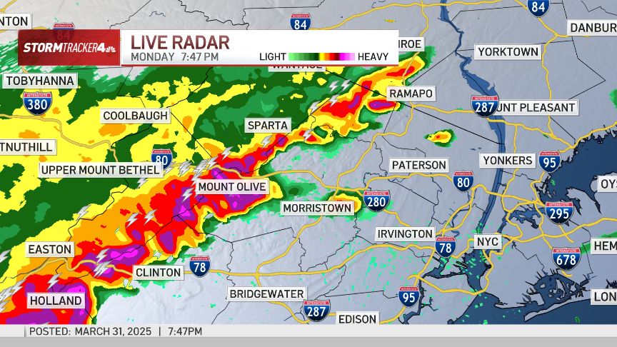
The line of storms is making its way east. It has already hit northern New Jersey, and will soon be hitting closer to the New York City area.

As of 8:45 p.m., there were already heavy downpours in Westchester and Rockland counties in New York, as well as northern Bergen County in New Jersey. Essex and Bergen counties looked to be getting hit before 9 p.m.

As for timing, Newark would be in the path of the storms around 9 p.m., followed by NYC around 9:30 p.m. Gusty winds and lots of lightning.

MAR 318:52 PM EDT

Severe Thunderstorm Warning issued for parts of NJ and the Jersey Shore

A severe thunderstorm warning was issued for southern Middlesex County, Monmouth County and Ocean County in New Jersey until 9:30 p.m.

The system heading east is capable of producing wind gusts of 60 mph and quarter-sized hail. It is heading out of eastern Pennsylvania and into Central/Southern Jersey.

MAR 318:12 PM EDT

Main line of storms bring downpours, lightning to Northern Jersey

Main line of storms has started arriving in Northern New Jersey, hitting western Morris and Hunterdon counties.

The storms will slowly migrate east. No severe warnings had yet been issued, but the systems were bringing heavy downpours and plenty of lightning.

Those in the impacted area should stay inside a secure building until the storms pass.

MAR 317:18 PM EDT

Newark Airport flight delays due to storms

Newark Airport was dealing with departure delays averaging about 25 minutes, according to Flightaware. Inbound flights were being delayed at their origin for about an hour and a quarter.

MAR 317:11 PM EDT

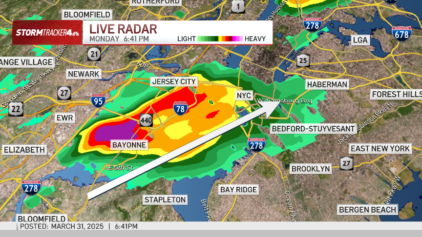
Downpour hitting lower Manhattan, Brooklyn and Queens

Heavy downpours were moving through parts of lower Manhattan, Brooklyn and Queens around 7 p.m.

Rainfall rates of 1-2 inches per hour had the chance to cause ponding and minor flooding, as well as brief traffic tie-ups as a result.

MAR 316:25 PM EDT

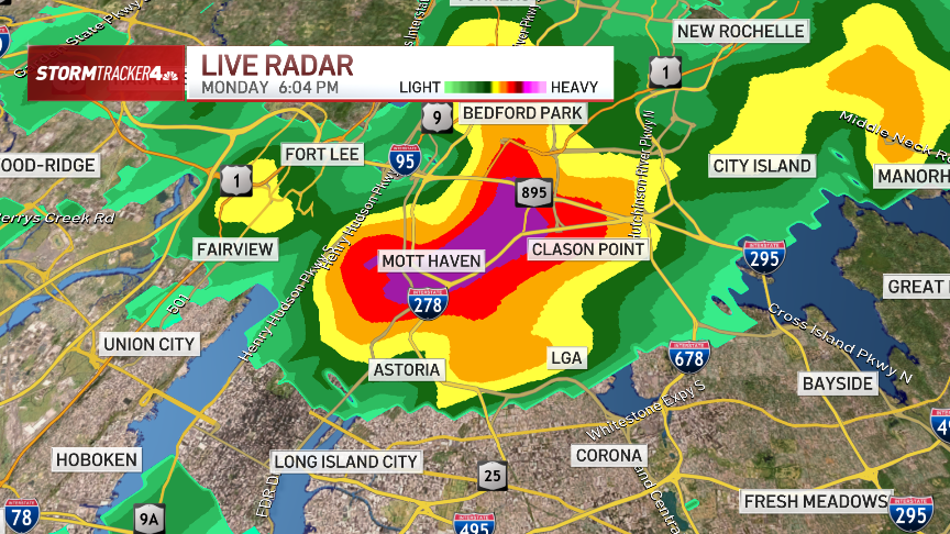
Flood advisory extends into Manhattan

The National Weather Service has extended its flood advisory for much of upper Manhattan, including the Upper East Side and Upper West Side, until 8 p.m.

The heaviest rain was hitting the area around Mott Haven and Clason Point in the Bronx around 6 p.m., as a strong storm cell moved through.

MAR 316:05 PM EDT

Flood Advisory issued for the Bronx and Bergen, Hudson counties

A flood advisory has been issued until 8 p.m. for Bergen and Hudson counties and the Bronx in New York City.

0.2-0.5 inches of rain is expected and officials are warning residents to not drive their vehicle into areas where water is covering the roadway.

"Heavy rainfall will cause flooding of small creeks and streams, urban areas, highways, streets and underpasses as well as other poor drainage areas and low lying spots," New York City emergency officials said.

MAR 315:40 PM EDT

PSE&G: ‘Prepared' for incoming storm, potential power issues

Utility company PSE&G said it's ready for any power issues that may arise from tonight's thunderstorms. The company said it has extra crews on staff to restore power if there are any outages or respond to any gas emergencies.

In the case of a power outage, PSE&G says you can report them and get status updates by texting OUT to 4PSEG (47734), through the company's app or on their website at pseg.com/myaccount, or call PSE&G at 1-800-436-PSEG (7734).  

Outages can be tracked at PSE&G's website here.

As of 5:40 p.m., there were 47 active outages affecting 91 customers.

MAR 315:35 PM EDT

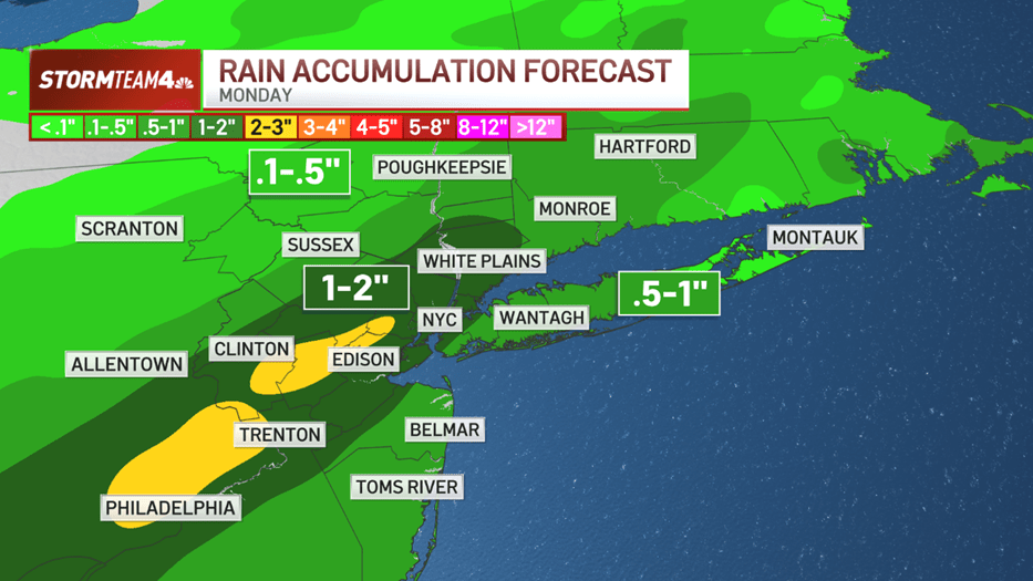
How much rain can we expect from Monday's storms?

Heavy downpours will be likely, but how much accumulation is the NYC area likely to see?

Overall, the storms will deliver a substantial amount of rain throughout the tri-state, especially along the I-95 corridor, where the heaviest pockets of rain will set up for a couple of hours.

In those spots, one to two inches of rain are likely, with isolated higher amounts. The rest of the area can expect anywhere from a half inch to an inch of rain, while those further north and west in the Hudson Valley will see comparatively lower totals, likely less than a half inch.

That amount of rain could lead to flooding, especially in low-lying areas.

MAR 314:42 PM EDT

Tornado risk not zero for tonight so make sure to stay ‘weather aware'

While a tornado occurring in the tri-state tonight is not likely, the risk is not zero. Storm Team 4 describes it as a tertiary threat with the chance existing of an isolated tornado or two, mainly west of the Hudson River. The National Weather Service's Storm Prediction Center puts the probability of a tornado around 2%, but the fact that it is not zero, is notable and worthy of our attention.

"The primary threat remains damaging wind gusts, with large hail also possible, and an isolated tornado cannot be totally ruled out," the National Weather Service says.

Here's information from the NYC emergency management office on how to prepare for a tornado.

MAR 314:38 PM EDT

Timing of storms: Will commutes be impacted?

When will Monday's storms start hitting the New York City area, and how will the weather impact evening commutes? That depends on where you are.

Those in NYC, Northern Jersey, the Hudson Valley and Connecticut could be dealing with thunderstorms or heavy rain as they drive home, and roads conditions could be heavily impacted. Those hitting the road should drive carefully.

Those along the Jersey Shore and on Long Island will have an easier time getting home, as the lines of storms won't have arrived there yet.

MAR 313:54 PM EDT

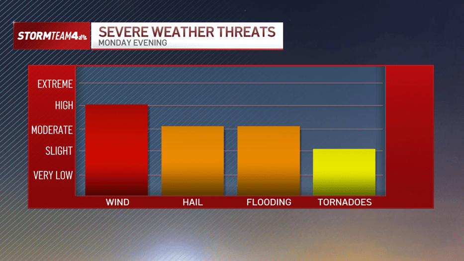
Monday evening's severe weather threats

Here's a breakdown of what weather threats we could be seeing this evening. Highest chance is for high winds, but hail and flooding from downpours also present a moderate threat.

While the threat for tornadoes is slight, any threat of that nature cannot be ignored.

MAR 313:53 PM EDT

NYC warns of possible ‘minor' urban flooding

The city's emergency management office is warning of a chance of minor urban flooding in low lying and poor drainage areas as a result of tonight's storms.

The National Weather Service is warning residents to "Stay Weather Aware" and be prepared to shelter indoors.

MAR 313:31 PM EDT

Newark Airport sees afternoon delays ahead of storms

Newark Airport passengers are facing delays Monday afternoon as a severe line of storms prepares to move through New Jersey. The airport is in a ground delay with average departure delays of 77 minutes due to storms, according to the FAA site.

Delay times are expected to stretch to 80 minutes during the 7 p.m. hour and more than an hour and a half after 8 p.m., the FAA reports.

MAR 3112:59 PM EDT

Severe storms threaten NYC area: 60 mph winds, quarter-sized hail possible

Severe storms threaten NYC area: 60 mph winds, quarter-sized hail possible

The primary threats with this system will be destructive winds and potentially rapid rainfall; an isolated tornado, though, isn't out of the question. Here's the latest forecast breakdown for tonight's storms

A line of strong to severe storms is headed to the tri-state are Monday night. Damaging wind gusts, large hail, isolated flooding and even an isolated tornado are possible.

And the timing could make the evening commute a tricky one.

By late afternoon, isolated storms will begin popping up mainly to the west and northwest of New York City. They will not be widespread, but where they do develop, they’ll produce heavy rain and gusty winds.

Read Full Article

Contact Us