


Monday morning saw Hurricane Milton rapidly intensify from a Category 1 hurricane to a Category 5 over just 10 hours.
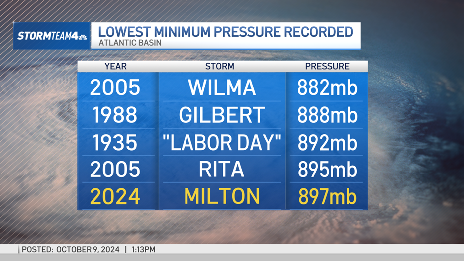
At peak intensity, sustained winds were topping out at 180 mph and the central pressure fell to 897 mb. This is the fifth-lowest central pressure ever recorded in the history of the Atlantic Basin. Now Milton is nearing the west coast of Florida, set to make landfall late Wednesday night.

Ahead of Milton’s official landfall, showers, destructive winds, and even tornadoes have already begun wreaking havoc on Florida. A tornado watch has been issued for the southern half of the peninsula.

Get Tri-state area news delivered to your inbox. Sign up for NBC New York's News Headlines newsletter.
Hurricane-force winds, upwards of 74 mph, extend about 35 miles out from the center of the storm while tropical-storm-force winds, 39-73 mph, extend out 250 miles from the center.


As Milton moves toward Florida, wind shear will weaken the storm, but not by much. Milton is still forecast to remain a major hurricane when it makes landfall late Wednesday night into Thursday morning as a category 3 or 4 hurricane. And the slight weakening will allow Milton to grow, further expanding the areas under the threat of Milton’s influence.
Milton is still forecast to remain a major hurricane when it makes landfall late Wednesday night into Thursday morning, likely as a Category 3 storm. And the slight weakening will allow Milton to grow, further expanding the areas under the threat of Milton’s influence.

Storm surge warnings are in effect from Cedar Key all the way down to the Everglades on the west coast and from Meritt Island up into southern Georgia on the east coast. Storm surge watches extend along the rest of Georgia’s coast and into South Carolina.
The precise location of Milton’s landfall will impact exactly where the worst of the storm surge sets up, but the current forecast has a potential storm surge of 10 to 15 feet occurring between Anna Maria Island and Boca Grande. Just on the periphery of this area are Tampa Bay and Charlotte Harbor, both of which are forecast for a storm surge between 8 and 12 feet. A shift or wobble in Milton’s track could change exactly where the worst of this storm surge is felt.

Further exacerbating the catastrophic storm surge is the timing of Milton’s landfall. Right now, Milton is forecast to come onshore late Wednesday night into Thursday morning. This would put timing very close to high tide in places like Tampa Bay; and higher tides lead to a greater storm surge, which is the last thing Florida needs.

Local


On top of the storm surge, Milton is expected to bring a substantial amount of rainfall to Florida. Totals will range between 6 and 12 inches for many, with some isolated totals nearing a foot and a half of rainfall.
But unlike the storm surge, which will be felt the most just south of where the storms makes landfall, the most intense rain bands are setting up north of the eye. Presently, places like Tampa, Orlando, and Daytona Beach are forecast to see some of the highest totals.
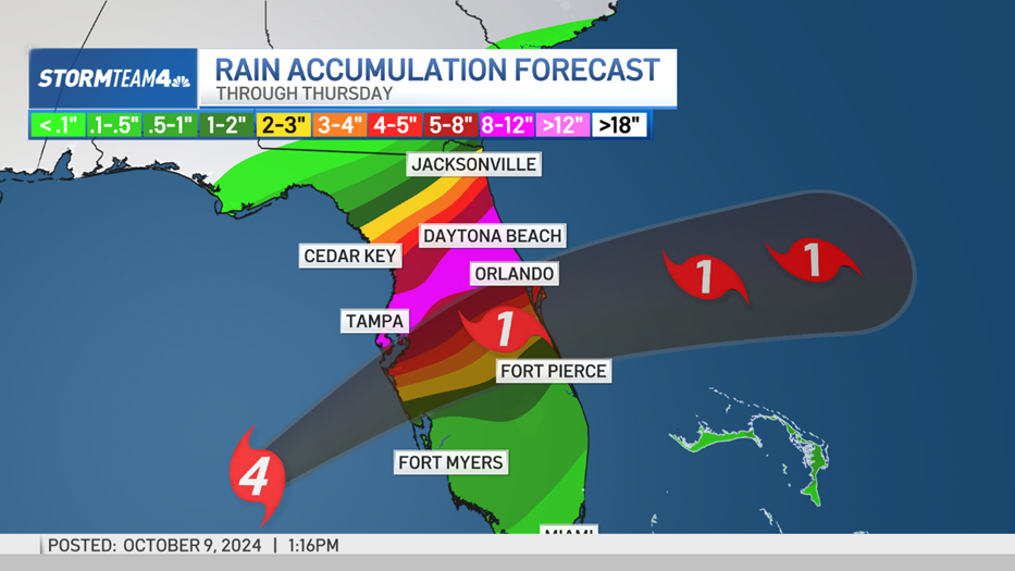
This amount of rain leads to an extensive amount of flooding, including river flooding and flash flooding. Most of Florida is under a flood watch. Flash flood warnings are already starting to be issued.
This will only increase as Milton progresses.


And all of this is coming to an area still recovering from Hurricane Ian two years ago, not to mention the destruction caused by Hurricane Helene just two weeks ago. The threat of any storm causing additional damage is terrible. But from a storm of Milton’s magnitude? Devastating.
