Latest Forecast From Storm Team 4
As of Wednesday afternoon, Hurricane Ernesto continued bringing heavy rain to the Virgin Islands and
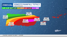
Puerto Rico. By midday Wednesday, between 2 and 6 inches of rain had fallen across Puerto Rico.
The highest totals are being reported on the eastern half of the island, where heavy rain banded over the region.
With more rain on the way, some areas had already tallied 10 inches of rain. An additional 2 to 6 inches is possible
before all the rain ends.
Watch NBC 4 free wherever you are
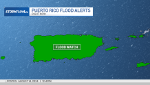
Flood watches remain in effect through Thursday morning. Excessive runoff could force rivers and streams to rise out of their banks, resulting in flash flooding. Mudslides are also a concern, especially in areas of steep terrain.
Get Tri-state area news delivered to your inbox with NBC New York's News Headlines newsletter.
As the week goes on, Ernesto will continue to strengthen as it travels north in the Atlantic.
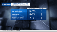
As early as Friday, Ernesto is projected to reach major hurricane status as a category 3. This would already be our second storm to reach major hurricane strength so far this season.
We expect Ernesto to approach Bermuda as a strong category 2 hurricane by the weekend. No watches or warnings have been issued yet for the island, but they are likely to be issued in the coming days.

How will Hurricane Ernesto impact NYC area?
Back in the tri-state, we are not expecting to see any huge impacts from Ernesto; the storm is staying far offshore. The one area where we expect to see some peripheral impacts from Ernesto is the beach.

By the end of the week, swells generated by Ernesto will reach the East Coast, contributing to higher surf conditions and a greater risk of dangerous rip currents. These impacts will stay with us through the weekend.
Weather Stories
We’ll also keep an eye on coastal flooding concerns. Ernesto’s influence combined with an onshore wind and a nearly full moon will lead to higher high tides, which could produce some minor flooding in low-lying areas and roadways.

