The first widespread winter storm of the year blanketed the tri-state area overnight and into the peak morning rush on Friday, dumping flakes at a rate up to 2 inches an hour at points as travel conditions turned hazardous across the region.
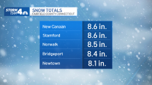
Areas closer to the shore where winter storm warnings were issued got more snow than inland areas, with spots in southern Connecticut, like Fairfield County, reporting the highest totals as the sun came up. (Check school closings here.)
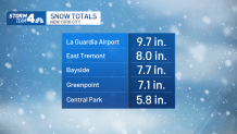
Locally higher amounts were possible, with LaGuardia reporting nearly 10 inches of accumulation, well more than expected, by about 3 p.m.
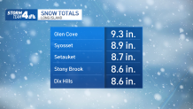
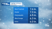
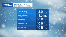
Most of the snow tapered off by mid-morning Friday. Check the latest snow totals from the National Weather Service in the map above or the graphics below as more updates come in:
Get Tri-state area news delivered to your inbox.> Sign up for NBC New York's News Headlines newsletter.
New York City
Long Island
New Jersey
Hudson Valley
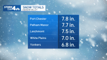
Connecticut
Get Tri-state area news delivered to your inbox. Sign up for NBC New York's News Headlines newsletter.
Weather Stories
How to Figure Out Your Own Total
If you want to be extra specific and see how much snow you got right outside, the National Weather Service suggests getting out your ruler.
Ideally, you'd want to plan ahead of the snowfall. But if you can find flat surfaces that are in a wind-sheltered area away from tall objects, you can take several measurements to find an average, the NWS said.
See the steps on how to measure and how to report below.
For the latest searchable snow total breakdowns in the New York metro area click here and for the latest county-level breakdowns click here. You can also check the map below for the latest updates as the National Weather Service updates its totals.

