Latest Forecast From Storm Team 4
Strong, dangerous winds will usher in below-freezing temperatures to start the workweek across the tri-state -- and it will remain gusty through Tuesday.
A high wind warning is in effect through Monday for most areas west of the city with gusts possible up to 60 mph. Meanwhile in New York City, Long Island, Connecticut, the Hudson Valley and Hudson and Bergen counties are under a wind advisory through Monday.
Watch NBC 4 free wherever you are
The high winds have the potential to bring down tree limbs and powerlines after all the ice accumulation from freezing rain Saturday night into Sunday. The wind gusts are apparently to blame for topping over a tree onto a home in Queens Monday morning. (Thankfully, no one was hurt in that incident.)
Due to the high winds, New York City's Office of Emergency Management is urging people to be careful outside.
Get Tri-state area news delivered to your inbox with NBC New York's News Headlines newsletter.
"Use caution when walking, biking, or driving," the city said. In addition, due to the winds, empty tractor trailers and tandem trailers are banned from using all MTA Bridges.
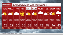
Monday will also be much colder with temperatures starting in the 20s and wind chills in the teens.
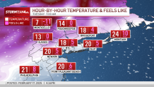
Winds back off a bit Tuesday, but it gusts will still remain. Expect winds between 30 and 35 miles per hour Tuesday. Not high enough to cause damage or power outages, but the wind will make it feel very cold as temperatures stay below freezing through Thursday.
Weather Stories
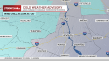
Feels-like temperatures drop to the single digits overnight in the NYC metro area. Meanwhile, in the mountains of Sullivan and Ulster counties, they will drop below zero – to as low as -20 – which has prompted a Cold Weather Advisory for those two counties for the overnight hours through Tuesday morning.
However, there is good news! The potential snow storm we’ve been watching for Thursday looks like a no-go for the tri-state. The storm drops too far south of us to impact the area. That leaves us dry this week, with our next chance for any precipitation (in the form of rain, most likely) next Monday.
Temperatures will start to warm back up for the weekend and the following week with a drier forecast ahead once we get through Thursday. Highs will stay below freezing through Thursday. After that, a slow warm-up to near-normal temperatures (low 40s) by the weekend.