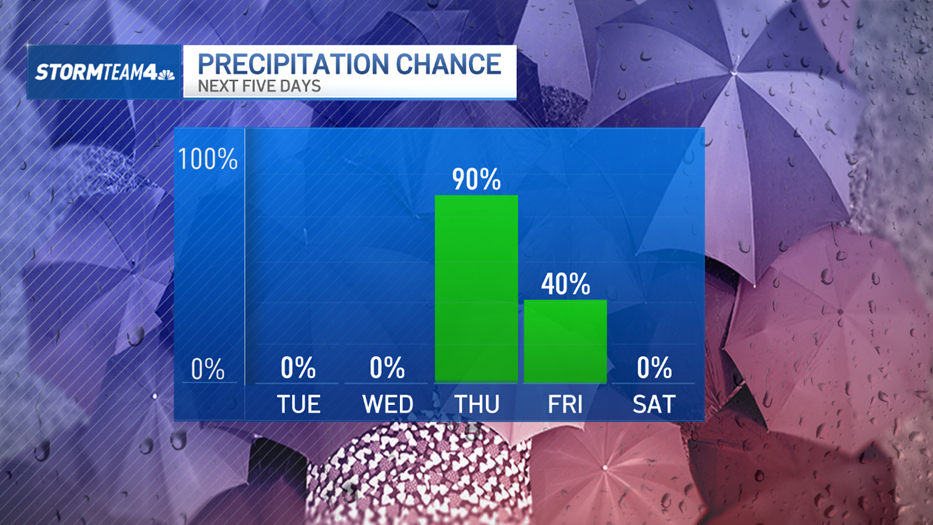
After weeks of missed rain chances, extreme fire danger, and an exploding drought, desperately-needed rain is on the way. And this time it’s more than just a trace.
While most of the tri-state, including the immediate New York City metro area, will see rain, at higher elevations north and west of the city, residents will see their first snowfall of the season.

It has been an exceptionally dry fall. Season-to-date, Central Park is running 9 inches below normal. And this is a trend seen across region; every major reporting site in the tri-state is down over half a foot at least.

These deficits have led to expanding drought conditions, with most of the area now under a severe drought. Our area has not seen drought conditions this bad since 2002.
Get Tri-state area news delivered to your inbox. Sign up for NBC New York's News Headlines newsletter.
This week’s rain won’t completely erase the deficit we’ve built up this fall, but it is going to go a long way in helping to ease some of the strain we’ve been under. Reservoir levels in New York State have been greatly diminishing. They typically operate around 79% capacity; current levels are at 60%, with individual locations as low at 20%.


Expect steady rain to arrive late Wednesday overnight into Thursday morning, with some of the heaviest rain coming during the AM commute. Another push of steadier rain will move through late Friday night.
Area-wide, we are expecting one to three inches of rain, with the higher accumulations setting up near the city and into the Hudson Valley.


Thursday morning’s rain is coming along a cold front. Behind the front, cold air takes over, dropping temperatures considerably heading into Friday. But most of us, especially in the metro area, will stay above freezing, meaning all precipitation we get will fall as rain.

Snow forecast for Thursday into Friday
Weather Stories
However, to our north and west, especially in the higher elevations, temperatures will hit the freezing mark, meaning snow is possible.
Very light snow could fall in parts of the Catskills, Poconos and northwestern New Jersey. This will not bring blockbuster snow to the Hudson Valley, but anywhere from flurries to an inch is not out of the question.


Another weather-maker is slated to move through late next week, hopefully bringing us another chance for rain. Like this week’s storm, it may not erase our rain deficit or the drought, but it would be nice to finally see a change in the same old (dry) pattern.


