


Hurricane Milton made landfall Wednesday night in what looks to be a potentially catastrophic collision along the west coast of Florida, after millions were ordered to flee and officials warned that stragglers would face grim odds of surviving.
The powerful storm made landfall as a Category 3 hurricane near Siesta Key in Sarasota County just after 8:30 p.m., with sustained winds of 78 mph recorded in Venice, just south of where the eye was located. Gusts topping 100 mph were reported elsewhere, according to the National Hurricane Center.
The NHC had said during the afternoon that Milton was growing in size as it approached the coast. Life-threatening storm surge, damaging winds and flooding rains are expected across portions of central and southwestern Florida. A tornado watch blanketed the southern part of the state until 9 p.m.
While Milton isn't expected to have much impact at all on the tri-state area, much of Florida's heavily populated cities, including Tampa and Orlando, are directly in the path of the storm — home to many family, friends and loved ones for those in the New York City area.
Get Tri-state area news delivered to your inbox. Sign up for NBC New York's News Headlines newsletter.
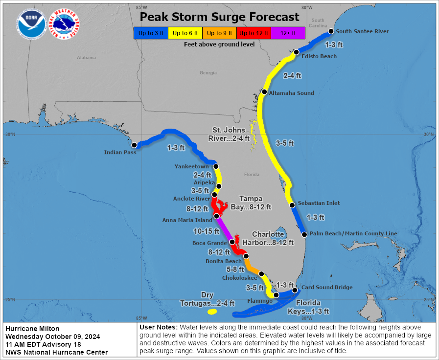
The Tampa Bay area, home to more than 3.3 million people, faced the possibility of widespread destruction after avoiding direct hits from major hurricanes for more than a century. The National Hurricane Center predicted Milton, a category 5 hurricane during much of its approach, would likely remain a major hurricane when it made landfall. While Tamps avoided a direct hit, areas just outside of the city could see a storm surge of up to 15 feet.
“Milton has the potential to be one of the most destructive hurricanes on record for west-central Florida,” the NHC warned.
More coverage

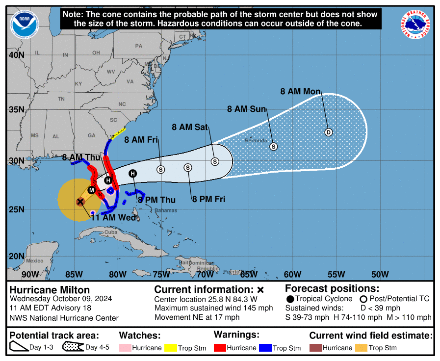


The National Hurricane Center stressed that it was not certain exactly where Milton’s center would come ashore Wednesday night because the storm's path might “wobble,” but that the entire Tampa Bay region and points south were at grave risk.
“This is it, folks,” said Cathie Perkins, emergency management director in Pinellas County, which sits on the peninsula that forms Tampa Bay. “Those of you who were punched during Hurricane Helene, this is going to be a knockout. You need to get out, and you need to get out now.”
Heavy rain and tornadoes lashed parts of southern Florida starting Wednesday morning, with conditions deteriorating as the day progressed. Six to 12 inches of rain, with up to 18 inches in some places, was expected well inland, bringing the risk of catastrophic flooding. Tornadoes were also a threat; one touched down Wednesday morning in the lightly populated Everglades area of South Florida and crossed Interstate 75.
Here's a look at the latest cone and potential weather hazards from NHC:
5-day cone: What is Milton's path?

Peak storm surge forecast

Rainfall potential


Flash flooding potential


Wind speed probabilities


