The latest update to the U.S. Drought Monitor was issued Thursday and the news isn’t good. The tri-state area is withering in a prolonged and increasingly extreme drought situation.
It started in September, when we got off to a very dry start. We ended the month with a large rain deficit. And then came October, We got a whopping 0.01 inch of rain, making October the driest calendar month in Central Park since record-keeping began in the 1860s.
So far, November is not breaking the mold. A week into the month and we’re still waiting for our first drop of rain.

The staggering extended run of dry weather has led to worsening drought in the tri-state area. The latest update to the drought monitor on Thursday shows every county within the area now under at least moderate drought conditions.
Severe drought in New Jersey has expanded from South Jersey into Central, and even parts of North, Jersey. And for the first time since Oct. 2002, parts of New Jersey are now suffering extreme drought conditions. That includes Ocean County.
Get Tri-state area news delivered to your inbox. Sign up for NBC New York's News Headlines newsletter.

The lack of rain is also impacting the New York reservoirs, which provide water to nearly half the state, including NYC. On average, the reservoirs sit at about 79% capacity. At present, the reservoir network is at about 64% capacity. Levels for individual sites vary, but 3 of the 7 locations are running at 50% capacity or lower, with the lowest at about 34%.

As a result of the lower water levels, NYC’s Department of Environmental Protection issued a drought watch, urging city agencies to reduce water usage. The watch also encourages residents to do their part to cut the amount of water they use, suggesting actions like shorter showers.

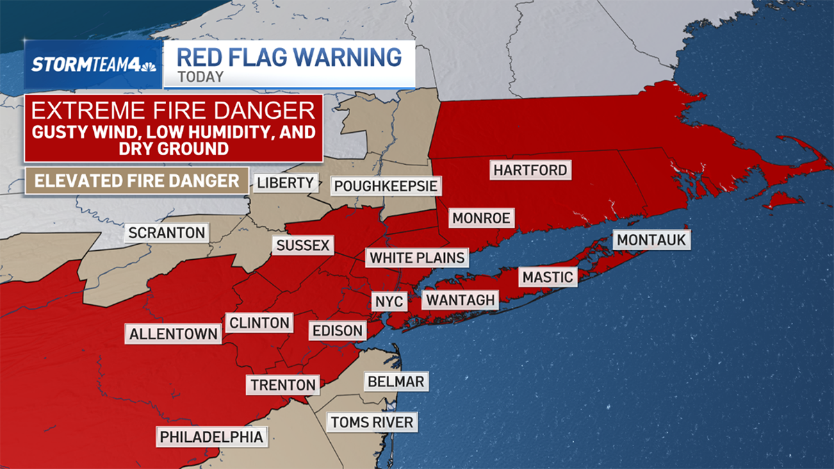
Widespread drought is also the leading factor in the persistent fire danger across the region. The dearth of rainfall has allowed for extensive amounts of available dry brush, which makes wildfires easy to start and quick to spread.

As a result, there are currently multiple active wildfires across the state of New Jersey. Some began as recently as this week, others have been burning since Halloween last month.

The wildfire danger can be amplified on a daily basis by low humidity and gusty. Relative humidity is a measure of moisture in the air. When it falls to near or below 30%, wildfires are easy to start. Gusty winds, particularly those over 25 mph, aid in the rapid fire spread, making any fires that do catch very difficult to contain.

Through the end of the work week, low humidity and gusty wind will be persistent and our fire danger will remain very high. Red flag warnings were issued Thursday afternoon for nearly a dozen New Jersey counties. Check the latest weather alerts in your neighborhood here.

Until we get meaningful rain and reduce our near-eight inch seasonal rain deficit, the fire risk will only get worse.
Weather Stories
Our next chance for rain comes Sunday evening, but it won’t be impactful. Anywhere from a tenth to a half-inch of rain is expected. And while any rain is worth celebrating at this point, this won’t scratch the surface of the rain we need to return to normal.


