
Keep the umbrellas handy. The unsettled weather pattern that kicked off the week is sticking around.
Scattered showers and storms are in the forecast everyday into the weekend. While none of these storms are expected to bring severe weather until Friday, some of the storms may produce isolated, flooding downpours. That threat is not considered widespread, however.
A “cold” front pushed through the area late Wednesday, taking the remaining showers and storms with it. Quiet weather is expected overnight and into early Thursday.
Unfortunately, the front is “cold” in name only. In reality, it is more of a wind shift and will not break our high heat and humidity. Highs could approach or top 90 degrees Thursday.

Heat advisories will remain in place for much of metro New York City and New Jersey. Heat index readings, or “feels like” temperatures, will hover between 95 and 100 degrees by Thursday afternoon.
Get Tri-state area news delivered to your inbox. Sign up for NBC New York's News Headlines newsletter.
Under a heat advisory through Thursday: New York City, Nassau, Essex, eastern Passaic, Union, Hudson, Bergen counties.
The heat and humidity on Thursday could spark showers and storms by the afternoon. These will be isolated and short lived, but enough of a nuisance to be aware of.

Dangerous heat continues into Friday for much of the tr-state, along with another chance for scattered afternoon storms. Isolated severe storms could develop in Central and South Jersey Friday afternoon.
The main concern with these storms is damaging wind gusts, capable of blowing off tree limbs and knocking down power lines.

The high temperatures peak Friday, with the heat index near 100 degrees. Sunday is trending drier, but even then a stray shower or two cannot be ruled out.
Weather Stories

Heat, humidity and scattered storms remain the weather headlines this weekend, too. With a moisture-laden atmosphere, showers can quickly turn into downpours, so exercise caution if you live in a flood prone area.
Rain totals through the weekend should add up to an inch or two area-wide. Parts of Long Island may end up with lower totals, near a half an inch. Hardest-hit areas could pick up as many as three inches. Coastal areas will probably get the least rain, which is good news for beach-goers.


Check StormTracker 4 on your NBC New York app frequently to know when the heavy rain is headed your way!
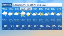
Check out your 10-day NYC forecast outlook below.
Track any approaching rain using our interactive radar below.