
The tri-state has already gotten deluged by storms once this week, and it appears likely to happen again heading into the weekend.
Spots from northern New Jersey, across New York City and onto Long Island measured anywhere from 2-4 inches of rain Tuesday night, with some areas tallying upward of five inches. But more soaking rainfall will be on its way Friday.
There won't be much in terms of precipitation before that time. Wednesday and Thursday will be damp and dreary with scattered showers, but not total washouts. The flood threat through Thursday will be low, but after Tuesday’s soaking even a little rain could cause minor flooding.


Get Tri-state area news delivered to your inbox. Sign up for NBC New York's News Headlines newsletter.
News


The outlook changes on Friday. Heavy rain returns to the region, thanks to the remnants of Debby.
Debby will push tropical moisture onshore as it moves north and merges with a stalled front. The flood threat in the northeastern U.S. will increase as rain ramps up Friday afternoon and evening as Debby approaches.
Rainfall rates up to 1-2 inches are possible, making flooding is a chief concern associated with this system. Thanks to a recent update in Debby’s track, the worst of the rainfall and storms is now expected to pass west of the NYC metro area. That will shift the greatest flood threat into the Mid-Hudson Valley, Catskills and Poconos.


Overall, around 1-3 inches of rain can be expected to fall closer to coastal areas, with some 3-4 inch totals farther inland. This is in addition to the 2-5 inches of rain that fell on Tuesday.
Keep in mind, Debby still needs to make a second landfall in South Carolina and travel across five or six states before approaching, so impacts and timing of the storms are subject to change.
Tuesday’s sizeable rain totals coupled with an already soggy start to August has left lots of saturated ground. This can make it difficult for the ground to absorb additional rain, resulting in minor flooding. The same is true for rivers, creeks and streams — which are already swollen from Tuesday’s rain and will have to handle much of the runoff from Friday’s downpours, leading to even higher levels and a higher flood risk.
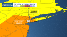
In addition to heavy rainfall, Friday comes with a marginal risk for severe weather. The main concern will be damaging winds. Gusts could exceed 50mph, strong enough to blow limbs off trees and knock down power lines.
Showers and storms will continue to track through our area, until they finally move offshore early Saturday morning. When that happens, humidity will drop significantly and sunshine will increase throughout the day and leave us with a beautiful weekend overall.
Sunday into the start of next week looks lovely.
Track any approaching storms using our interactive radar below.
