
More soaking rainfall associated with the remnants of Tropical Depression Debby is expected to seize the tri-state area Friday, days after powerful storms dumped 2 inches of rain an hour — and there's even a chance for tornadoes.
The weakened Debby will merge with a front and head north through Pennsylvania and New York before passing into Canada Thursday night and into Friday. Any rain through early Friday will be light and scattered, but as the remnants of Debby pass just west of the tri-state, heavier downpours and strong to severe storms will become an issue.
Debby will push tropical moisture onshore as it moves north and merges with a stalled front. The flood threat in the northeastern U.S. will increase as rain ramps up Friday afternoon and evening as Debby approaches. Rain and storms pick up in the late afternoon and into the evening when heavy rain and severe weather are likely.


Get Tri-state area news delivered to your inbox. Sign up for NBC New York's News Headlines newsletter.
News


Rainfall rates of 1-2 inches an hour are possible again as they were earlier in the week, making flooding a chief concern associated with this system. The worst of the rainfall and storms is now expected to pass west of the NYC metro area. That shifts the greatest flood threat into the Mid-Hudson Valley, Catskills and Poconos.
Thankfully, Debby will not stall over our area the way it did along the Carolina Coast. Rather, it will move through quickly, keeping rainfall totals in check. By comparison, areas in North and South Carolina picked up close to a foot of rain in 24 hours while Debby was stalled overhead.
Near the coast, rain totals will stay below 2 inches in most places.


Some isolated areas could see 3-to-4-inch totals further inland. This is in addition to the 2 to 5 inches of rain that fell on Tuesday.
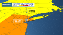
In addition to the flood threat, severe storms could do damage Friday. The main concern will be damaging straight-line winds. Gusts over 50mph could snap tree limbs and knock down power lines.
In addition, weak short-lived tornadoes will be possible, especially in Pennsylvania, western New Jersey and the Catskills region. An isolated tornado or two could pop up anywhere in the tri-state area though, so make sure you have a way to get severe weather alerts on your phone.
A great way to do that is by downloading the NBC New York app and turning on weather alerts.
Heavy rain may plague Pennsylvania and Upstate New York for much of the day Friday. In the Metro NYC area, the timeline will be more narrow – between mid-afternoon and mid-evening.
Rain lingers till midnight or so, and the good news is that all precipitation will exit the area by the start of weekend, leaving us with sunshine, lower humidity and comfortable temperatures both Saturday and Sunday.

Sunday and into the start of next week looks lovely.
Track any approaching storms using our interactive radar below.
