
What to Know
- A tornado watch is in effect for a swath of New Jersey and New York's Hudson Valley through early Friday afternoon; Debby's remnants are moving through
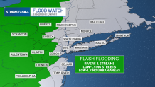
- They're expected to bring torrential rain and strong winds into the evening hours; rainfall rates of 1 to 2 inches an hour are possible, making flooding a chief concern associated with this system
- The worst weather is expected to pass west of the NYC metro area, putting the greatest flood threat in the Mid-Hudson Valley, Catskills and Poconos
More soaking rainfall associated with the remnants of post-tropical cyclone Debby is forecast to seize the tri-state area Friday, days after powerful storms dumped 2 inches of rain an hour — and there's even a chance for tornadoes.
A tornado watch issued for more than a half-dozen counties in New Jersey, along with New York's Hudson Valley and Pike County in Pennsylvania, has been extended through 10 p.m. Check the latest weather alerts for your neighborhood here. A tornado watch means conditions are favorable for tornado development.
Watch NBC 4 free wherever you are
Get Tri-state area news delivered to your inbox with NBC New York's News Headlines newsletter.
Debby’s remnants have merged with a cold front moving north toward Canada. The system will pass through New York Friday afternoon on a fast track to Canada, bringing showers and storms to the tri-state area, especially north and west of New York City.
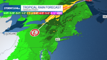
Rainfall rates will be highest closer to the track of low pressure. One to 2 inches an hour could lead to accumulations nearing 4 inches in isolated spots. This amount of rain could be devastating, especially in areas that are still saturated from Tuesday’s soaking.

News


Thankfully, Debby will not stall over the region the way it did along the Carolina coast. Rather, it will move through quickly, keeping rainfall totals in check. By comparison, areas in North and South Carolina picked up close to a foot of rain in 24 hours while Debby was stalled overhead.
Rainfall totals for most across the tri-state will be under 2 inches. Along the coasts and in the city, accumulations will be less than an inch. But further north and west, upwards of 2 to 3 inches could fall.
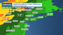
August has started soggy and it won’t take much additional rainfall to trigger more flooding, especially in low lying areas.
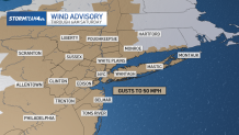
Beyond the flood threat, gusty winds could do their share of damage. Our entire area is under a wind advisory on Friday, indicating wind gusts throughout the day could reach up to 50 miles an hour.
Gusts at this strength could snap tree limbs and knock down power lines.
In addition, weak, short-lived tornadoes will be possible, especially in Pennsylvania, western New Jersey and the Catskills region. An isolated tornado or two could pop up anywhere in the tri-state area though, so make sure you have a way to get severe weather alerts on your phone.

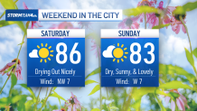
The good news is that rain will exit the area before sunrise on Saturday, leaving us with sunshine, lower humidity and comfortable temperatures for the rest of the weekend.
Track any approaching storms using our interactive radar below.
10-day NYC forecast outlook
