After a quiet and pleasant start to the week, another round of summer swelter and severe weather is headed toward the tri-state area on Wednesday — and this one brings the threat of tornadoes to the region.
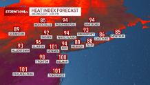
First comes the extreme heat. Temperatures will soar into the 90s for most on Wednesday, with dew points back into the upper 60s making it even more uncomfortable.
That level of heat and humidity will make temperatures feel like the upper 90s to near 100 degrees in some areas. The combination has prompted a heat advisory for Central and South Jersey.
Get Tri-state area news delivered to your inbox.> Sign up for NBC New York's News Headlines newsletter.


News
Prolonged exposure to that level of heat can be dangerous for your health. During peak heating of the day it is a best practice to limit time outside, avoid strenuous activity and drink plenty of water.
The good news: The heat is going to be short-lived. The bad news: The relief comes from a cold front that also brings severe storms.
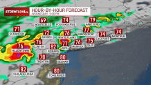
Through most of the afternoon, our battle will only be with the heat. With the exception of a few spotty showers or storms by the evening commute, it won’t be until later in the evening that storms become a more widespread concern.

If you can leave work a little early Wednesday, it might be a good idea to avoid the rain entirely. Certainly, storm coverage and intensity will increase as the evening goes on, so avoid driving on the roads late at night if you can.
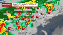
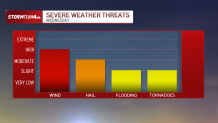
Storms will produce abundant lightning and some are expected to produce damaging wind and hail. Lesser concerns will be isolated minor flooding and pop-up tornadoes, which would be concentrated in and around North Jersey to the west of NYC.

If Wednesday night is when you put out the garbage or recycling, consider waiting until Thursday morning so your bins don’t get blown down the block. Wind gusts could exceed 60 mph. Unstable trees or dead branches could come down in the storms, too.
Hail up to an inch in diameter could fall. That’s big enough to put dimples in a car.
As for the tornado risk, it’s low. If any do spin up, they would likely occur west of New York City, where conditions are most favorable. Expect any that do form to be short-lived and produce very localized winds from 80 to 100+ miles per hour, which could topple trees and do damage to homes.
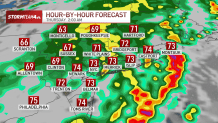
The storm threat will mainly be from mid-evening to shortly past midnight, with the worst weather window lasting from 5 p.m. to 11 p.m. Rain will continue overnight, but the severe threat will be diminished after about 2 a.m.
When the showers have moved out, temperatures return close to average and humidity comes back down to a comfortable level, giving way to a gorgeous end of the workweek.