One more round of rain. Then we get a very nice, late summer reward.
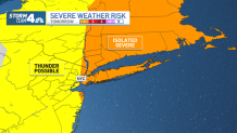
A few strong storms could roll in from the west overnight as a cold front approaches, approaching some of the counties to the far north and west of New York City around 4-5 a.m. That brings the timing for the storms to hit the NYC metro area right around the start of the Friday morning commute.
That could spell trouble for those who don't have summer Fridays (or get to work remotely to end the week). While the severe threat isn't overly high, brief heavy rain, localized flooding and strong winds are all possible with the storms.

Get Tri-state area news delivered to your inbox.> Sign up for NBC New York's News Headlines newsletter.
By late morning or around noon, any lingering storms will likely be further to the east, or at least deeper in Connecticut. It then gets breezy in the afternoon, but this will usher in dryer and more comfortable air for the afternoon and weekend.
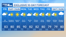
That's when we get our reward: gorgeous weekend weather with highs in the low to mid-80s, very low humidity and clear skies.
Nearly all of next week looks clear as well, but it's summer, so that could change if a stray thunderstorm happens to pop up. Stay tuned to Storm Team 4 for the latest updates.
See Storm Team 4's exclusive 10-day forecast below:


