Latest Forecast From Storm Team 4
After a stormy start to Friday, another round of severe weather was set to hit the tri-state through the afternoon, potentially bringing flash flooding, intense winds and even a chance for tornadoes.
The overnight storms pushed through New Jersey around sunrise, trigging severe thunderstorm watches for portions of the state. That line of storms weakened as it made its way east, and brought more scattered showers to spots closer to the city.
But the second round of storms could be more dangerous, possibly posing a bigger risk for severe weather.
Watch NBC 4 free wherever you are
The P.M. storms will be more scattered than the one seen during the morning systems, and are expected through the Hudson Valley, south through NYC and into New Jersey — where the strongest storms may be more likely. Damaging straight line winds, hail and flooding are the biggest threats, although most areas were not expected to see more than a couple inches of rainfall. Tornadoes can't be ruled out either.
A severe thunderstorm watch has been issued through 8pm for the eastern Hudson Valley into Connecticut.
Get Tri-state area news delivered to your inbox with NBC New York's News Headlines newsletter.

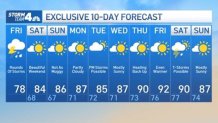
The rain should clear out by Friday evening, paving the way for a spectacular weekend. Temperatures will stay about normal for this time of year and the humidity should be moderate. And for what seems like the first time in forever, it appears it will be a rain-free weekend.
Weather
The next chance of rain comes Tuesday, with another round of 90-degree days on its heels, as next week could end with a heat wave.
See below Storm Team 4's exclusive 10-day forecast: