Raphael Miranda provides a weather update for News 4.
What to Know
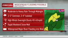
- Up to 4 inches are rain is expected across part of the tri-state area through early Wednesday morning. The rain will fall on top of up to a foot of snow cover in some interior locations, leading to flooding concerns, which will continue for days as rivers rise
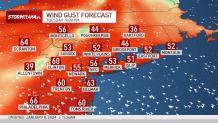
- Wind gusts will get above 60 mph in some areas, leading to power outage worries, especially on the Jersey Shore and Long Island. Storm Team 4 is predicting widespread major river flooding throughout the area. New Jersey Gov. Phil Murphy has declared a state of emergency beginning at 5 p.m. Tuesday. New York City has issued a travel advisory for the duration of the storm
- Once we get through Tuesday's storm and the impacts from that, we are watching another rain system for Friday night into Saturday that could bring lower rain amounts but would come on top of very saturated grounds and potentially higher rivers
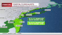
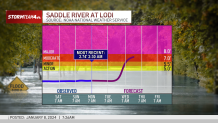
Flood warnings are in effect for much of the New York City metro area as the second major winter storm of the season -- this one bringing heavy rain -- threatens extreme flooding and wind damage across the entire tri-state.
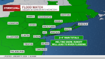
A widespread 2 to 4 inches of rain is expected to fall on the tri-state by Wednesday morning. That comes on top of the foot-plus of snow that fell in some spots this past weekend and as parts of New York and New Jersey still struggle to recover from last month's floods.
Watch NBC 4 free wherever you are
Flood warnings were issued by the National Weather Service for many counties until 1 a.m. and a Flash Flood Warning was issued for part of Nassau County on Long Island until 2 a.m.
The National Weather Service also issued a flood warning for New York City until 2:30 a.m.
Get Tri-state area news delivered to your inbox with NBC New York's News Headlines newsletter.
Power outages are being reported across the tri-state with the numbers growing by the hour. As of 10 p.m., around 20,000 customers were without power in the NYC metro area with the highest number in New Jersey.

Track the rain using our exclusive StormTracker 4 interactive radar below.
Several school districts announced delays for Wednesday morning and check the latest alerts for your neighborhood.
Overnight, delays were being reported at JFK (3 hours) and LaGuardia (2 hours) with hundreds of flight cancellations across the tri-state, according to the FAA. Newark Liberty was also reporting extensive delays. Amtrak was also reporting a number of cancellations, according to the city's emergency management office.
A number of road issues were being reported by the NYPD, including on the southbound FDR Drive, southbound Henry Hudson Parkway, northbound Bronx River Parkway, and northbound Cross Island Parkway.
LIRR needed to suspend service between Oyster Bay and Mineola around midnight due to a downed wire at Glen Cove. Metro-North was also reporting delays and the need to skip some stations due to downed trees. NYC Ferry's Rockaway and St. George routes have been suspended due to the high winds.
The Staten Island Ferry warned of delays and disruptions through Wednesday morning and recommends passengers leave extra time commuting.
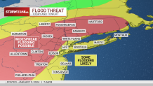
Many of the full effects of the storm may not be known until Wednesday and Thursday as local rivers rise.
Gov. Phil Murphy announced a state of emergency would take effect at 5 p.m. Tuesday, allowing resources to be deployed throughout the state during the duration of the storm.
"This storm will exacerbate the effects of the inclement conditions we experienced in December and this past weekend and may precede another storm Friday night," Murphy, a Democrat, said in a statement. "As always, I urge all New Jerseyans – including residents in our coastal and riverine communities – to follow all safety protocols and remain off the roads unless absolutely necessary."
Paterson Mayor Andre Sayegh declared a state of emergency starting Tuesday evening. A Red Cross shelter will be opening at 60 Temple Street for residents who choose to leave their homes ahead of the storm. High-water vehicles and water rescue boats are on standby to assist in rescuing residents if needed.
In nearby Newark, public safety officials released a list of commonly flooded intersections people should avoid.
The city of Hoboken declared a state of emergency and urged residents to avoid flood-prone areas and avoid driving during the height of the storm.
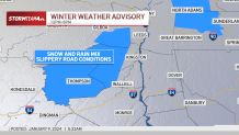
Heavy rain, especially on top of the weekend snow cover, is expected to make it an impactful storm.
New York City issued a travel advisory for the duration of the storm, warning about the difficulty of travel and getting around during the peak of the rain Tuesday evening.
The rain will continue to get heavier throughout the night. Temps will climb into the 50s, and that, combined with the heavy rain, will lead to rapid snow melt. Track StormTracker 4 live here.


Widespread river flooding is expected across New Jersey and the lower Hudson Valley, particularly the areas with snow cover. Some flooding may be severe.
Track the rain and wind forecasts hour by hour.
New Jersey dealt with extensive flooding in late December, and many are still struggling with the damage.
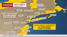
Winds will also be a concern, with gusts topping 60 mph on Tuesday night. Power outages and downed trees can be expected, especially on the Jersey Shore and the South Shore of Long Island. Gusts could also be particularly problematic on Staten Island.
The rain should wind down before Wednesday's morning commute, but high winds are expected to linger.
A high wind warning will be in effect starting Tuesday at 6 p.m. through Wednesday morning for Staten Island, Brooklyn, and parts of Queens, Suffolk, and Nassau counties in New York. Winds were impacting travel by mid-Tuesday afternoon, with the New York City Ferry having to suspend service on the Rockaway route.
Brooklyn's Floyd Bennett field, which had been housing about 2,000 migrants in emergency shelter amid the crisis, had to be evacuated over related concerns.
"The health and safety of migrants in our care is always a top priority, which is why we are currently overseeing the relocation of 1,900 guests from the humanitarian emergency response and relief center at Floyd Bennett Field due to an updated forecast with increased wind speeds estimated to be at over 70 MPH tonight," a city spokesperson said.
"To be clear, this relocation is a proactive measure being taken out of an abundance of caution to ensure the safety and well-being of individuals working and living at the center," the person added. "The families are already in the process of being temporarily relocated and will continue to be provided with essential services and support. The relocation will continue until any weather conditions that may arise have stabilized and the facility is once again fit for living. We are actively monitoring the situation and will issue updates as necessary."
In New Jersey, Monmouth, Ocean, Cumberland, Atlantic, and Cape May counties are subject to the high wind warning. The southern half of Fairfield County in Connecticut is also under the warning.
More weather stories


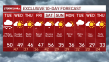
What's next? Check out the 10-day forecast
Once this mess moves out, we're looking at temperatures in the high 40s Wednesday as well as residual flooding. The weather briefly improves for the end of the week, with mostly sunny skies and mid-40s forecast for Thursday.
More rain could return as early as Friday evening. Thunder is also possible. This one could begin briefly as wintry precipitation for far northwest counties. Another significant batch of rain could be part of the system this weekend.
Next weekend looks iffy at this point, but there's plenty of time for the forecast to change. By Sunday, though, expect it to feel like winter outside. Sign up for our newsletters here.