Another round of storms pummeled the tri-state overnight and into the morning, dumping large amounts of rain and threatening to bring additional weather threats through Tuesday morning.
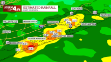
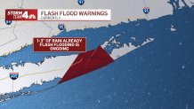
The threat of severe weather started around midnight and will stick around through Tuesday morning. A flash flood watch remains in effect until 10 a.m., while a flash flood warning was issued for parts of eastern Long Island. Some of the heaviest rain has been in Suffolk County, from near Brookhaven up though the Twin Forks.
The rain moved out for much of the rest of the tri-state by 6 a.m. or so, dropping around an inch of precipitation in many spots. A few localized areas may have picked up a couple of inches, with Westhampton getting nearly three inches, according to the National Weather Service. Shirley and Mastic Beach also topped two inches.
The biggest thing to look out for was the potential for heavy rain and flash flooding, which had potential to wreak havoc on the morning commute. The flash flooding also posed a threat for those who live in areas that frequently see water levels rise amid bouts of heavy rain.
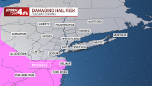
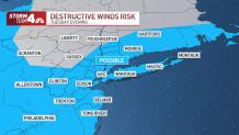
The greatest risk for damaging winds, even a tornado or two, was set to be closer to the Philadelphia metro area, but wasn't out of the question for areas in and around New York City.
Get Tri-state area news delivered to your inbox. Sign up for NBC New York's News Headlines newsletter.
News
After a midday break, which will be cloudy and humid, more scattered storms are possible during the afternoon and evening — some of which could be strong to severe. The main timing for that would be around 5 p.m. - 11 p.m.
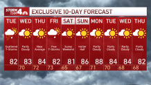
The rest of the work week looks primarily clear, with mostly sunny skies and highs in the low to mid 80s. Then storms close out the week on Friday before another front clears out the area for the weekend.
The areas most at risk to see severe weather Tuesday night are the Jersey Shore and eastern Long Island.
Much of next week looks clear, but it's summer, so that could change if a stray thunderstorm happens to pop up. Stay tuned to Storm Team 4 for the latest updates.
See Storm Team 4's exclusive 10-day forecast below:
