The first major snow storm of the season has mostly cleared out and left behind significant snow totals for some in New York and New Jersey, while others woke up Sunday to nothing but wet roads.
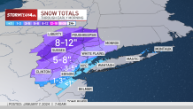
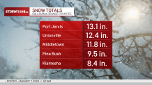
The overnight system brought snow accumulations as high as a foot for parts of Orange, Ulster and Sussex counties -- and it only took 12 hours to reach those totals.
Central Park did not reach an inch of snow and the nearly two-year drought of not a single day of more than an inch of snow continues.
Get Tri-state area news delivered to your inbox.> Sign up for NBC New York's News Headlines newsletter.
How much snow did your town get?
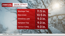
Parts of the Hudson Valley and northern New Jersey got more than a foot of it -- and the heavy, wet stuff is likely to cause headaches for anyone breaking out their shovels for the first time this season.
Local
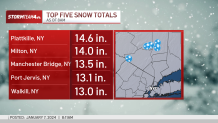
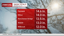
Here's a look at some of the biggest totals from around the tri-state, with New York's Plattkille seeing the most as of Sunday morning — at 14 inches!
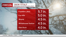
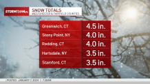
New York City was once again left out of the snow party. Central Park barely recorded more than a trace and the rest of the five boroughs was lucky to see anything stick to patches of grass.
Here's a look at some of the snow totals closer to NYC:

An earlier commercial vehicle restriction on many of New Jersey's interstate highways was lifted as of 8 a.m. Sunday.
Storm Team 4 is warning of possible ice early Monday for the morning commute and to take it slow on the roads.
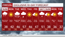
What's next? Check out the 10-day forecast
We're tracking another big storm on the heels of this one. The next system looks to hit Tuesday into Wednesday, and with temperatures expected to be relatively warm, that may mean flooding rainfall, on top of any snow that has accumulated and could melt. Sign up for our newsletters here.
Track any approaching precipitation using our interactive radar below.

