We’ve been saying it for weeks, and the words ring truer by the day: This has been an exceptionally dry Fall.
We got an inch and a half of rain in September, with most of that coming at the tail end of the month. October has been even drier, with weeks passing without a measurable drop of rain at Central Park. And the consequences of such a persistent dry stretch are getting significant.

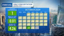
Since 1869, when records started being collected in Central Park, we have never gone an entire calendar month without measurable rain. On Tuesday, 29 days into the month, we finally managed to accumulate the minimum amount of measurable rain: 0.01 inches.
Get Tri-state area news delivered to your inbox.> Sign up for NBC New York's News Headlines newsletter.
That’s all we’re going to get for the month, and it makes Oct. 2024 the driest calendar month on record, edging out June 1949, when we got 0.02 inches.


Weather Stories
A bone-dry October preceded by an arid September has left us with a season-to-date deficit of seven inches across the two months. This is the driest start to fall since the 19th century (for history buffs, it dates back to the Benjamin Harrison administration).
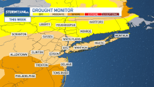
The lack of rain is taking a toll, most notably in the form of a drought. In early September there was no drought in the region. As of the latest update to the drought monitor on Oct. 31, the entire state of New Jersey is now in at least a moderate drought conditions. More than half of the state is now in a severe drought.
For perspective, severe drought conditions have not covered 50% of New Jersey since 2002.

The expanding drought is leading to elevated fire concerns across the tri-state. Wind gusts, relative humidity and a dearth of rainfall are all factors that impact the fire danger in a given location. Our parched landscape alone has promoted high fire danger on most days in the past two weeks.
Lack of rainfall produces tinder-dry brush that is ripe for combustion. Low humidity makes fires easy to start and gusty winds cause fires to spread quickly. When all of these factors work together, they make for extreme fire danger conditions.


Presently, both our winds and humidity are in check. Our main fire hazard is the dry brush that has been become increasingly plentiful due to our lack of rain. And this has been the primary driving factor that has led to the high, and at times extreme, fire danger across the tri-state.
Red flag warnings have been issued for nearly the entire tri-state area for Friday, as the combination of gusty wind, low humidity and dry ground make for an extreme fire danger.

Thursday's weather did nothing to help the situation: More dry weather paired with temperatures that matched or broke record-high temperatures in the afternoon.
Islip, on Long Island, reached 80 degrees on the day, shattering the previous record of 73 from two decades ago. Record highs from 1946 were broken at LaGuardia Airport, Newark Airport and Poughkeepsie, while Central Park matched its record high set on this day 78 years ago.

It just hit 81 in Central Park. Everyone gets a record! https://t.co/imq37Xxsgi pic.twitter.com/91rmXy8igT
— Storm Team 4 NY (@StormTeam4NY) October 31, 2024
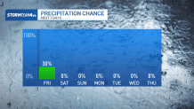
The fire concerns are only going to get worse as our rain deficit continues to grow. Friday morning is our next chance for rain, but it will barely register in the rain gauge. We’ll be lucky to pick up more than a hundredth of an inch. That is nowhere near enough to make a dent in our deficit.
And, as minimal as it is, this could be our last chance to see any rain in a while as we look to enter yet another extended dry stretch next week.


