Latest Forecast From Storm Team 4
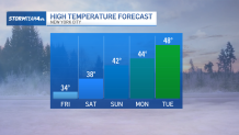
While temperatures will continue to be colder-than-normal for the next few days, a warming trend begins after Thursday.
Temperatures are climbing back into the 40s by this Sunday; we’ll even see highs above average by next week. Stay bundled up just a little while longer — you’ll be able to shed a layer or two soon.
Watch NBC 4 free wherever you are
A weak upper-atmospheric low pressure system passing through late Thursday brings flurries and a few light snow showers to the tri-state, but not much else.
Temperatures through Thursday night remain below freezing, so whatever does fall will fall as snow. Accumulations will be minimal, less than an inch throughout the region, but timing will coincide with the evening commute, so there may be a few slick spots on area roads.
Get Tri-state area news delivered to your inbox with NBC New York's News Headlines newsletter.

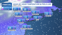
As skies dry out and clear overnight, the wind will ramp up just in time to make the wind chill a factor Friday morning through afternoon.
With winds gusting 25-35 mph, wind chills will be in the low 20s at best.
We begin to feel the warm-up beginning Saturday, as the wind settles and temperatures continue to rise. And, unlike the last two weekends, we’re going to stay dry all weekend.
Local


It’ll be a great opportunity to get outside and enjoy the sunshine, especially on Sunday.
And if the low 40s doesn’t sound warm enough, temperatures continue to rise into the upper 40s by next week.
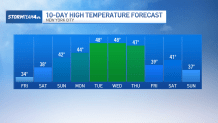
Unfortunately, these milder temperatures don’t have much staying power. A cold front is coming through by the end of next week to knock temperatures back down into the low 40s and upper 30s just in time for the start of March.
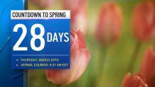
It looks like we’re going to have to wait a little longer for the warm temperatures to stick around. The good news: the start of spring is only a month away!