Latest Forecast From Storm Team 4
It’s been a steamy summer week in the tri-state, but you may have noticed a bit of a break Thursday. No, it’s not your imagination.
In fact, the long-running heat advisory in place for most of the week was even allowed to expire because of the modest reduction in humidity.
But don’t get used to it. The sultry summer feel is returning as we head into the weekend. It starts with a return to high-level humidity on Friday combined with an increased risk for showers and storms.
Watch NBC 4 free wherever you are

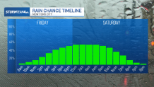
Showers and storms will begin to bubble Friday along the I-95 corridor. They will continue on-and-off through Saturday afternoon and early evening as a low pressure area rides up the coast.
Get Tri-state area news delivered to your inbox with NBC New York's News Headlines newsletter.
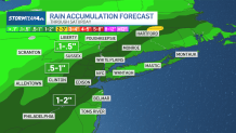
The atmosphere this weekend will be laden with deep tropical moisture, so pockets of heavy rain are possible, and that could lead to isolated flooding. A flood watch has been issued for central New Jersey from Friday morning through Saturday afternoon.
Weather Stories


Downpours could disrupt your outdoor plans briefly and cause very difficult driving. Watch out for ponding on roads Friday and Saturday where the rain is coming down hard. Two-day rain totals will average anywhere from a half inch to two inches in most places.
The good news is that we’re not anticipating any other severe weather for the rest of this week. Atmospheric conditions are not conducive for strong storms that could produce damaging wind gusts, large hail or tornadoes.

Once the rain clears the area, we dry out Sunday — and are right back in a steamy summer stretch of extreme heat.
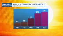
Expect another heat wave starting Sunday and extending through the middle of next week. Temperatures will range between 90 and 95 degrees with afternoon “feels like” temperatures between 95 and the low 100s.
There is also a chance for storms for much of next week through Thursday.
But there is a small bit of good news: It does look like temperatures could come back to Earth a bit by the end of next week. Highs could be closer to normal, in the mid 80s, just in time for next weekend.
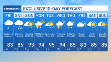
Check out the exclusive 10-day forecast below: