What to Know
- It's looking like this winter will be a record-setter for NYC, with no measurable snowfall expected in Central Park through the rest of this month at least
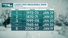
- The latest date New York City has ever recorded snow accumulation is Jan. 29, which occurred in 1973
- Some showers are possible Wednesday (mostly rain, but some snow could mix in) before temps fall starting Thursday. But that system doesn't appear to be posing much of a threat for major impacts
In case you were wondering when New York City might see some real snow, here's a something of a hint: We're going to be much, much closer to reaching the 50-degree mark than the freezing mark every day until the middle of next week.
So to answer the question: Don't expect any legitimate snowfall for the near future.
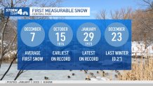
That means the five boroughs are all but certain to set a record for the latest-ever date to see the first measurable snowfall of the season. The current record is Jan. 29, but it sure looks like we'll breeze right past that and go right into February without significant snow.
Get Tri-state area news delivered to your inbox.> Sign up for NBC New York's News Headlines newsletter.

In fact, the forecast for the record-setting day, on Monday, calls for partly sunny skies with temperatures in the mid-40s. That sounds a lot more like a day in early Spring rather than late January.
That will be part of a generally quiet weather pattern that kicks off Thursday and stretches into the middle of next week. Expect temperatures in the mid to upper 40s for that time, with partly sunny or cloudy skies.
Some showers are possible on Wednesday (mostly rain, but some snow could maybe mix in) before temperatures fall starting Thursday. But that system doesn't appear to be posing much of a threat for major impacts — meaning we may go through the first weekend in February without much snow to speak of.
Another storm looks like it could brush by the area come the following Saturday, but it’s far too early to give specifics on how much, if any, snow will fall. At least it will feel like winter, as a cold shot of Arctic air will arrive by then, keeping temperatures below freezing for a few days.
That will likely at least bring conditions that would, theoretically, make snowfall possible. Stay with Storm Team 4 for all the latest updates to see if anything changes.

In a winter that has seen parts of the country walloped by historic snowstorms, including other areas of the Empire State, NYC has been notably bereft of the white stuff. Bereft might be too light a term, considering we haven't seen any measurable snow at all thus far -- and we're well over a month into the season already.
Wednesday looked like the day that could all change, but any snow that was falling in the city changed over to rain by the afternoon, leaving just a trace amount of snow.
The latest date New York City has ever recorded accumulation is Jan. 29, which occurred in 1973.
First Central Park Snow Averages

Yes, we've technically seen snowflakes this season, but trace amounts of snow mixed in with rain don't count for weather data recording purposes. (That's not us, that's the National Weather Service.)
Last winter, Central Park recorded its first measurable snowfall on Dec. 23, although it was only 0.2 inches (so, you see, "trace" amounts are really nothing at all). The average first measurable snowfall in the city is Dec. 7, so we're already a month behind the average.


