What to Know
- Another stormy day awaits the area on Tuesday -- although, not at the level we saw the day before.
- Tuesday should start on a dry note, but there is another chance for storms in the late afternoon. We are not expecting the same coverage or intensity as Monday, but storms can once again contain heavy rain, gusty winds and lightning.
- The main risk of the day should be a risk of damaging wind and some hail, mostly in central and southern New Jersey. But anyone in the tri-state could see a thunderstorm.
So Monday was a mess, but what does the rest of the week look like?
Another stormy day awaits the area on Tuesday -- although, not at the level we saw the day before when storms left downed trees and more than 11,000 power outages as of Tuesday morning. Travelers are also dealing with frustration at area airports as the severe weather has impacted flights and has caused residual delays and and flight cancellations. (Click here to see if your flight was delayed or canceled.)
Tuesday should start on a dry note, but there is another chance for storms in the late afternoon. We are not expecting the same coverage or intensity as Monday, but storms can once again contain heavy rain, gusty winds and lightning.
The main risk of the day should be a risk of damaging wind and some hail, mostly in central and southern New Jersey. But anyone in the tri-state could see a thunderstorm.
Whatever does come down will likely surface around the afternoon and evening, before drying out again overnight.
Get Tri-state area news delivered to your inbox. Sign up for NBC New York's News Headlines newsletter.
Timing out Tuesday morning, we can expect a bit of a lull. The area will see some residual effects from Monday's rainfall with some flooding, some patchy fog, and cloudy skies. Come midday, there is a chance of showers and storms, but this really picks up as we head into the late afternoon and evening, before we see it quiet down quite a bit overnight.
News
Check the latest weather alerts for your neighborhood here.
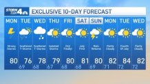
A few storms are possible yet again on Wednesday, but we’ll dial down the coverage each day. By Friday, it looks like we may get a quiet day, but the break won’t last long—rain returns Saturday night into Sunday.
The good news is that most of the July 4th week should be sunny, dry, and warm.


