
Rain returned Friday, with intensifying scattered showers and storms expected to dump up to 4 inches of rain on parts of the tri-state area through Saturday evening.
Showers and storms began to bubble up along the I-95 corridor in the afternoon, amid heightened humidity. They will continue on and off through Saturday afternoon and early evening as a low pressure area rides up the coast.
The atmosphere is laden with deep tropical moisture, which provides the fuel for downpours. That will make pockets of heavy rain possible, which could lead to isolated flooding.

A flood watch has been issued for most of the tri-state area, including much of New York City, from Friday morning through Saturday afternoon. Pockets of heavy downpours that could lead to quick flooding of streets and streams. Check the latest weather alerts for your neighborhood here.
Most areas will pick up under two inches of rain through Saturday. However, where the heaviest downpours occur, rainfall rates of up to 2 inches per hour are possible, and that could lead to higher totals.
Get Tri-state area news delivered to your inbox. Sign up for NBC New York's News Headlines newsletter.


Weather Stories
These heavy downpours will be isolated, so not everyone will get caught in one. But if you, do you could pick up two to four inches of rain in a couple of hours. That’s when flash flooding can happen. The best thing to do in this situation is to stay inside until the deluge passes.
To stay a step ahead of the rain, pay close attention to StormTracker 4 on the NBC New York app. It will tell you where the rain is at any given time, and where it’s headed.
The good news is that we’re not anticipating any other severe weather to accompany this system. Atmospheric conditions are not conducive for strong storms that could produce damaging wind gusts, large hail or tornadoes.
So far this summer, total rainfall in NYC is running four inches below average. This is reflected in a drought monitor that shows a growing area of unusually dry soil. Much of New Jersey also falls into the “unusually dry” category, and a few areas are even experiencing moderate drought.
As a result, while this weekend’s rainfall is good for the region, the flood threat is troublesome. When the ground is dry it cannot absorb rainfall at the same rate as moderately moist soil.


Once the rain clears the area, we dry out Sunday — and are right back in a steamy summer stretch of extreme heat.
Expect another heat wave starting Sunday and extending through the middle of next week. Temperatures will range between 90 and 95 degrees with afternoon “feels like” temperatures between 95 and the low 100s.


There is also a chance for storms much of next week, through Thursday.
The silver lining: Temperatures (and more importantly humidity) will finally come back to Earth by the end of next week, with highs retuning to the mid-80s in time for next weekend.
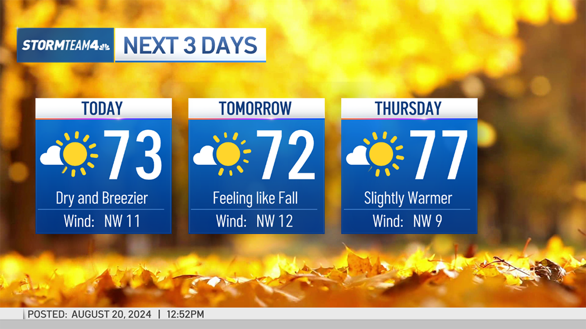
Check out the exclusive 10-day forecast below:

Track any approaching storms using our interactive radar below.
