
With "back-to-school" season in full swing, the tri-state is splitting into two camps: Those who are ready for the cool days and crisp nights of fall, and those who wish summer heat would never end.
In the short term, the summer lovers will win – and likely get more than they bargain for. Extreme heat is set to take over the area Wednesday and brings with it a threat for strong to severe storms. Check the latest severe weather alerts here.
A heat advisory goes into effect at 11 a.m. for New York City and neighboring counties in all directions. Nearly all of New Jersey will be under at least a heat advisory, with temperatures topping 90 degrees and high humidity that translates to heat index readings as high as 103 during the hottest part of the day. From Trenton to Philadelphia, an excessive heat warning will be in place for heat indices up to 105.
Watch NBC 4 free wherever you are

Air conditioning will be your friend Wednesday. Minimize your time outside. If you do have to be outside, be sure to stay well-hydrated, do not over-exert yourself, and stay in the shade as much as possible.
Get Tri-state area news delivered to your inbox with NBC New York's News Headlines newsletter.
A code red alert was issued for the city of Newark, which advised at-risk residents (senior or those with chronic health issues) to take precautions and for everyone to check in on neighbors who may be on their own. The city also advised that air quality is expected to be unhealthy for sensitive groups.
The heat advisory will remain in place until 8 p.m., after which temperatures should fall below the danger zone. By Thursday, temperatures will be significantly cooler, reaching only into the 70s.

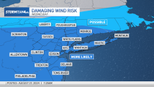
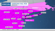
Most of Wednesday will likely be rain-free, but storms should fire in the late afternoon or evening ahead of a cold front. They will not be widespread, but those that do develop could be strong to severe. Central and South Jersey are more likely to feel the punch.
Weather Stories

The primary storm threats are damaging straight-line winds and large hail. Wind gusts could exceed 50 mph, strong enough to blow limbs off trees and knock down power lines.
Hail produced could be over an inch in diameter. At that size, hail could inflict minor property damage, like cracking a car windshield or denting its hood.


Once the storms and the associated cold front move through, temperatures and humidity decrease significantly. We go from highs that are nearly 10 degrees above average to highs that are almost 10 degrees below average.
Temperatures stay moderate for the rest of the 10-day weather forecast. We've got another chance for showers and storms on Saturday as the week's second cold front pushes through the region. The rest of Labor Day weekend should be warm and mild (though it most certainly won't be a pretty one for travelers).
Looking ahead, days start to feel more autumn-like, and by next week morning lows will drop back into the 50s. Jacket weather!

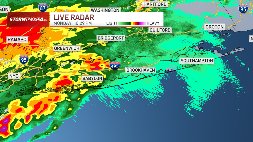
Track any approaching rain using our interactive radar below: