What to Know
- Strong storms are expected to bring lightning, hail and damaging winds to our area Friday; the greatest risk in terms of timing lasts until 8 p.m. so expect a potentially problematic commute
- Most will see less than half an inch of rain from these storms. But others, especially in the Hudson Valley and around the five boroughs, will see totals closer to an inch
- In addition to the threat of severe weather, the New York Department of Environmental Conservation issued an air quality health advisory for the NYC area from 11 a.m. until 11 p.m. Friday. The primary concern is ozone, according to the DEC; vulnerable groups should take cautions
Temperatures are heating up. And Friday is all about the sticky, sweaty, and stormy weather.
After a relatively quiet morning and early afternoon, tri-state weather started to become unsettled from during the late afternoon, and is expected to stay that way through the early evening.
When you step outside, you’ll be able to feel the stickiness in the air. High humidity means there's a lot of moisture in the air to fuel heavy downpours.
It wasn't until the afternoon and early evening, as a cold front approaches and temperatures peak for the day, that the strong line of storms started to move through our area. But the timing will vary depending on your location.
Get Tri-state area news delivered to your inbox.> Sign up for NBC New York's News Headlines newsletter.

Local
For those farthest north and west in the Hudson Valley, storms started popping off in the late afternoon with some storms lingering into the start of the evening commute. All severe thunderstorm warnings had expired by 7:30 p.m., though a severe thunderstorm watch remained in effect for much of New Jersey until 9 p.m.
For the Lower Hudson Valley, north and central New Jersey, Connecticut and New York City's five boroughs, timing falls during the peak evening commute, until 8 p.m. If you need to be on the roads at this time, be prepared for slowdowns and make sure to budget extra time. Drive carefully and expect to see ponding on low-lying roads.

South Jersey and Long Island can anticipate the bulk of their storms to come through between by 10 p.m. This will interfere with the evening commute and any plans to drive down the shore ahead of Father’s Day weekend.
In terms of travel delays, the NYC-area airports were seeing delays of nearly two hours due to the storms Friday evening.
There were reports of some downed trees and localized flooding throughout parts of the tri-state, but no severe damage had been reported.
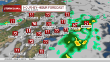
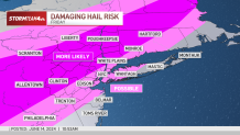
No matter where you are, these storms have the potential to be severe, with damaging winds and hail as the chief concerns. Wind gusts could top 50 mph
Winds of this strength can damage trees and knock down power lines.
Large hail produced by this system may reach an inch in diameter and result in minor damage to property.

Most will see less than half an inch of rain from these storms, though parts of the Hudson Valley and New York City could see closer to an inch or more.
The speed of this system keeps rain totals manageable and reduces the risk for widespread flooding, though isolated minor flooding is possible.
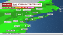
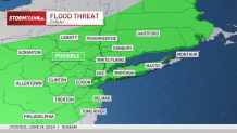
New York Gov. Kathy Hochul also issued an advisory regarding the storms, with flash flooding, dangerous travel conditions and power outages all possible.
Air quality alert issued
In addition to the threat of severe weather, the New York Department of Environmental Conservation issued an air quality health advisory for the New York City metro region from 11 a.m. until 11 p.m. Friday. The primary concern is ozone, according to the DEC. The Air Quality Index is expected to hit levels that are unhealthy for sensitive groups.
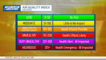
Check the latest weather alerts for your neighborhood here.
Active children and adults and people with respiratory problems, like asthma, should reduce prolonged or heavy exertion outdoors, experts say. Officials also suggest more breaks. It advises people to watch for symptoms like coughing and shortness of breath and to follow the action plan they've pre-determined with their providers.
Storms are completely out of our region before sunrise on Saturday. Clouds clear, humidity tumbles, and we’re left with a gorgeous weekend, including a picture-perfect Father’s Day.
Heat wave on deck
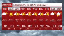
The first potential heat wave for 2024 may hit from Tuesday to Friday, with elevated humidity levels making it feel even hotter — as heat index levels could top 100 degrees.
"New Yorkers should take every precaution they can over this next week to stay cool and stay safe as the combination of severe storms, heat, and humidity will pose a significant health risk for vulnerable New Yorkers,” Hochul said.
