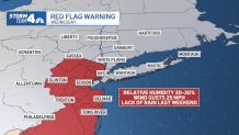
Even though most of us had never heard of "red flag warnings" before this month, much of the region is now very familiar with the term — and the danger that can accompany it.
A week after a rash of brush and wildfires that burned thousands of acres in New Jersey, The National Weather Service blanketed the Garden State with more of those enhanced fire danger alerts Wednesday — and conditions will likely bring more on Thursday. The warnings come as a result of humidity levels once again having dropped, leaving relatively dry air with warm temperatures and 25 mph gusts.
All that together combines for a higher risk for brush fires, which, when fueled by the strong winds, can spread quickly. Check the latest severe weather alerts for your neighborhood here.

A wildfire in Burlington County's Washington Township threatened as many as 30 structures at one point, but was 95% contained as of Wednesday night. No injuries were reported and no property was said to be damaged.
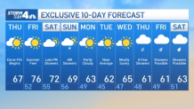
A warming trend begins Thursday, with temperatures capping off in the upper 60s, which is a touch above average for this time of year. But they'll hit the near 80 by Friday.
Get Tri-state area news delivered to your inbox.> Sign up for NBC New York's News Headlines newsletter.
Saturday will be warm as well, but a cold front will bring temps back to normal next week. Showers return, mainly by late Saturday into early Sunday. A few storms are possible, too, but the afternoon should be dry and cooler.
Much of next week is dry, so this will be much-needed rainfall. See the extended NYC weather outlook below.


