
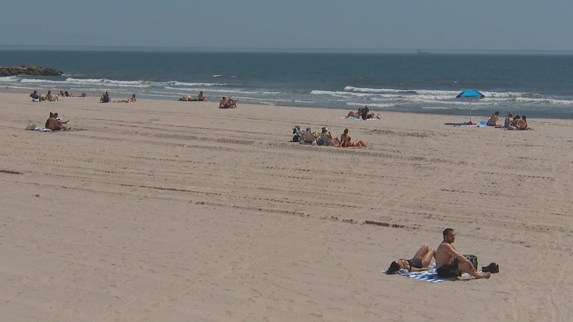
It's already the hottest year on record in New York City. And we're just warming up.
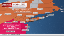
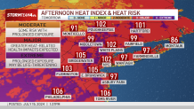
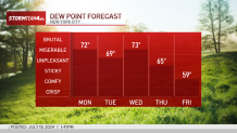
We’re turning up the temperatures again this week. Dangerous heat is expected through Wednesday as we spend multiple days in a row with highs in the 90s and heat indices getting into the triple digits.
The third heat wave in this unrelenting, miserable stretch of humidity is upon us.
Nearly the entire tri-state area is under heat alerts through Wednesday. North Jersey, the Hudson Valley, Connecticut, Long Island and New York City could experience feels-like temperatures up to 104 over the next few days, while Central and South Jersey could be feeling closer to 108 by midweek.
But no matter where you are, the heat and humidity be sweltering.
Get Tri-state area news delivered to your inbox. Sign up for NBC New York's News Headlines newsletter.
This level of heat, especially when it is prolonged for multiple days, makes it incredibly difficult for the body to cool itself. It is best to avoid strenuous activity, limit time spent outdoors and stay hydrated.
Check the latest weather alerts for your neighborhood here.

Weather Stories
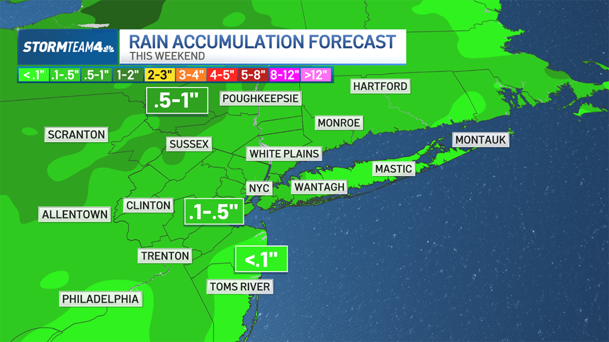
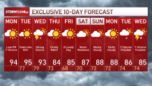
Along with the heat and humidity, we are expecting multiple chances for showers and storms over the next few days, some of which may be severe.
Here's a day-by-day breakdown for what to expect through the middle of the week:
Tuesday
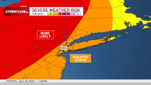
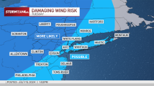
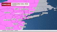
Tuesday’s heat brings another chance for showers and storms, as early as the evening commute. The greatest threat for severe weather remains north and west of the I-95 corridor, but now the entire region has at least a marginal chance to see some severe storms move through.
The main risks associated with this severe threat are damaging winds and hail up to an inch in diameter. At this size, hail can lead to some property damage. If you live within the risk area, try to park your car in a covered area — you don’t want hail to crack your windshield or dent your roof.
Wednesday
Despite the unsettled weather, these storms will not do anything in terms of providing relief from the heat and humidity; that does not come until late Wednesday with the passage of a cold front.
Wednesday begins like any other day this week: feeling brutally hot. Scattered showers will start to pop up by the afternoon, continuing into the evening. The entire day is not a washout, but it is one where you’ll want to have an umbrella close by.
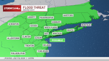
By the late evening and into the overnight, a final push of storms fire up as the cold front moves through the region.
This also brings with it the chance for isolated severe storms area-wide, with damaging wind gusts and minor flooding as the primary concerns.
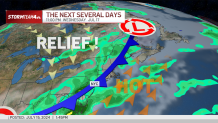
Once the showers and storms clear out early Thursday, both temperatures and humidity will see a significant decline. Highs will be back near July averages and humidity will return to a tolerable level. This will make the end of the week, much more enjoyable than the start.
If it's feeling like the hottest year in recent memory, it's not just in your head (or your sweat).
Storm Team 4 says 2024 is now the hottest year on record (to date). Our recent stretch of heat has helped bring our average temp just above previous records of 2012 and 2023.

Central Park has also hit 90 degrees 11 times so far this year (as of 7/13), with more 90-degree days expected this week.
Track any approaching storms using our interactive radar below.