The start of 2025 has been a chilly one. And temperatures have not bottomed out yet.
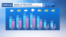
We’re looking ahead to a stretch of days next week that’ll be 5 to 10 degrees colder than anything we’ve experienced so far this year. In fact, we have not seen temperatures this cold in almost 2 years.
But the frigid air is not here yet.
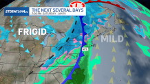
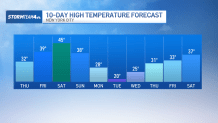
After a chilly Wednesday and Thursday, we’ll actually see temperatures swing back up and into the 40s this weekend. Unlike most of January, where we had a steady northwest wind delivering cold Canadian air straight to the tri-state, we’ll see our winds coming out of the south-southwest, delivering milder air to our region. Briefly.
Get Tri-state area news delivered to your inbox. Sign up for NBC New York's News Headlines newsletter.

As quickly as the milder air will move in, a cold front is set to come along to knock temperatures back down. The showers along this front will largely be rain, though some snow could mix in north and west as colder air flows into the region.
Following Saturday’s front, a secondary boundary moves through on Sunday, bringing the chance for some light evening snow, followed by a blast of arctic air behind it.

Then temperatures tumble heading into next week.
So far this year, the coldest temperature we’ve seen at Central Park has been 19 degrees. By Tuesday, our highs will struggle to reach that mark. And that’s before factoring in the wind chill, which will make it feel like the single digits for much of the day.

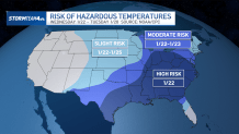
We have not experienced temperatures this cold since Feb. 2023. And this level of cold can be dangerous, especially when winds are factored in. Break out all of your winter gear and be prepared to layer up.
If you think it’s felt cold these past few weeks, just wait until the arctic air settles in.


