Latest Forecast From Storm Team 4
What to Know
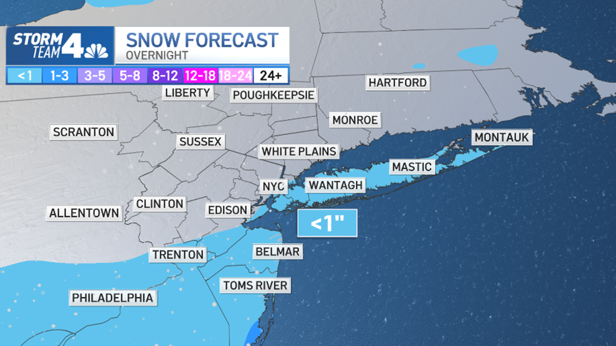
- Brace for cold weather by the end of the week — but first, there's a chance for snow in the city overnight into Wednesday, which would be a first this season. It would only be a tenth of an inch or so, but still would be more than Central Park has seen all winter so far
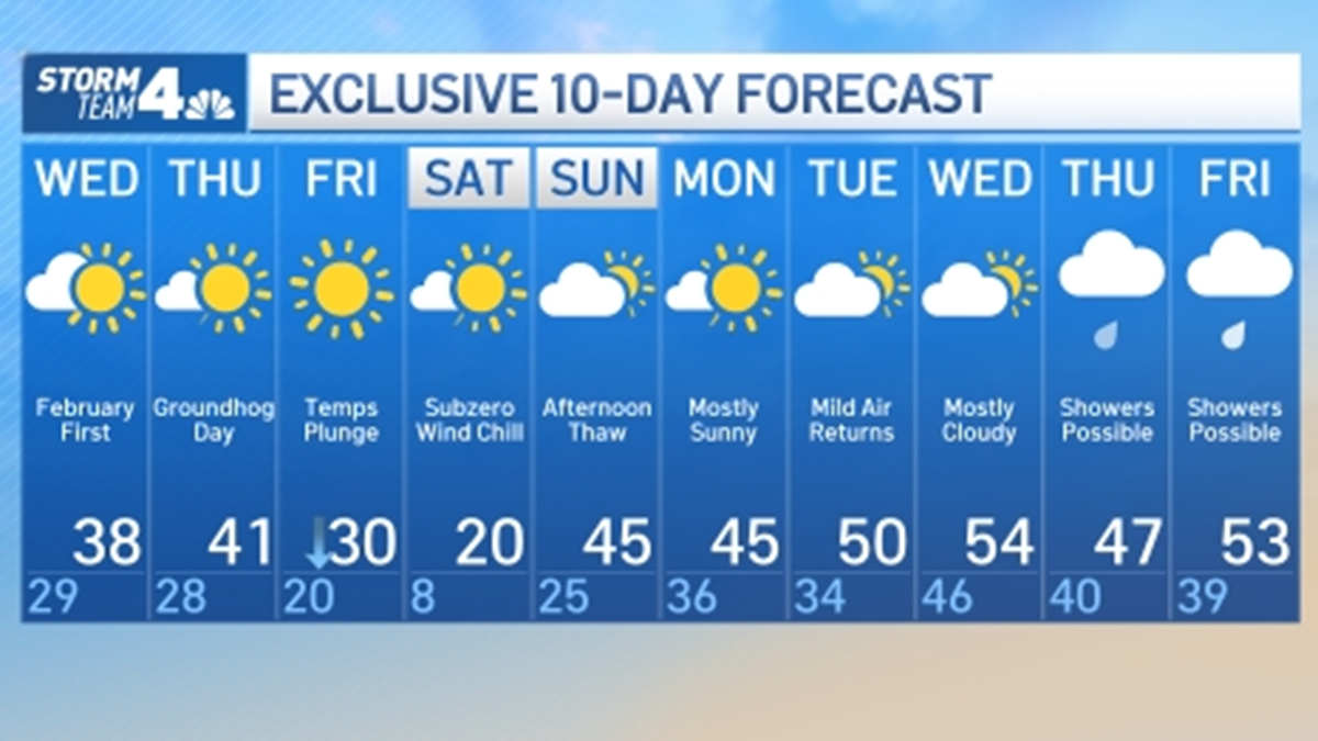
- Friday's highs will climb to around the freezing mark, then tumble ... and tumble, and tumble. Expect single-digit lows in NYC Saturday, with dangerous sub-zero wind chills across the metro area; temps rebound Sunday and stay milder for much of next week
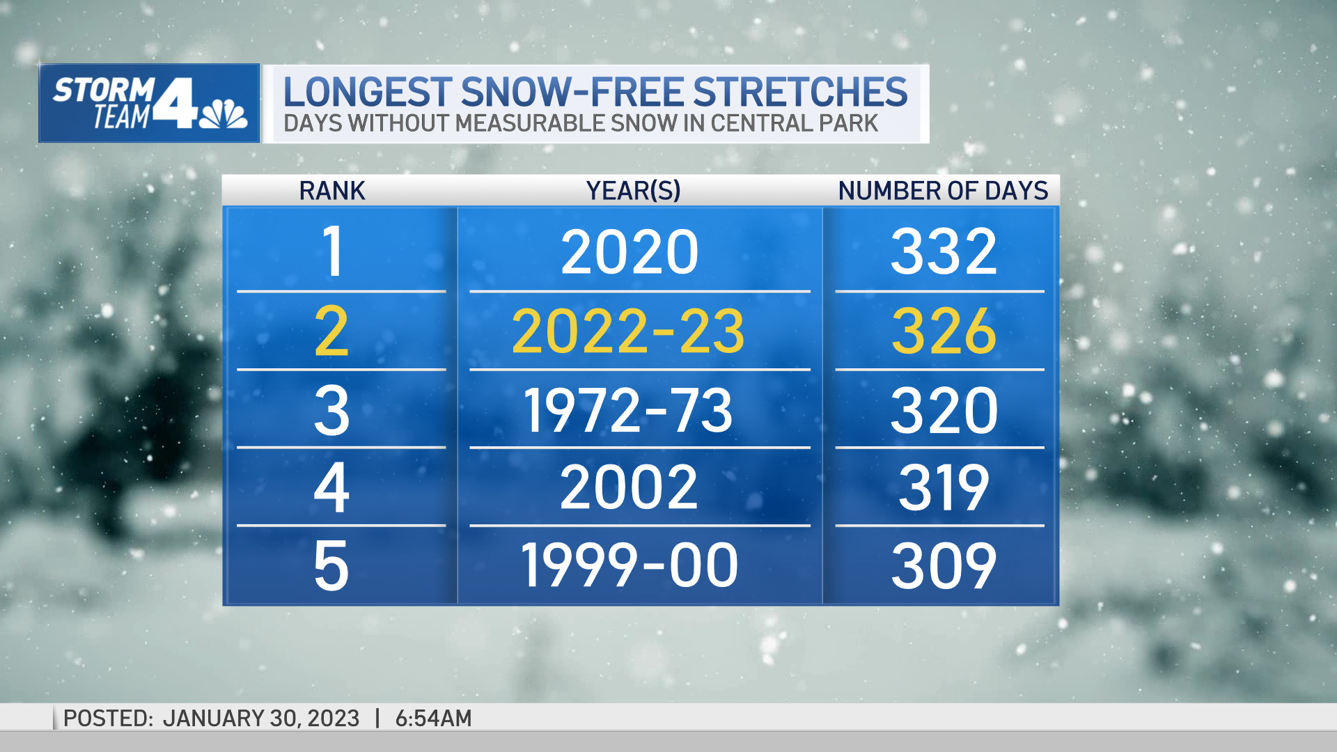
- If it yet again doesn't snow, NYC could set a record for longest snowless streak ever (333 days) should we make it through the weekend without seeing any of the white stuff
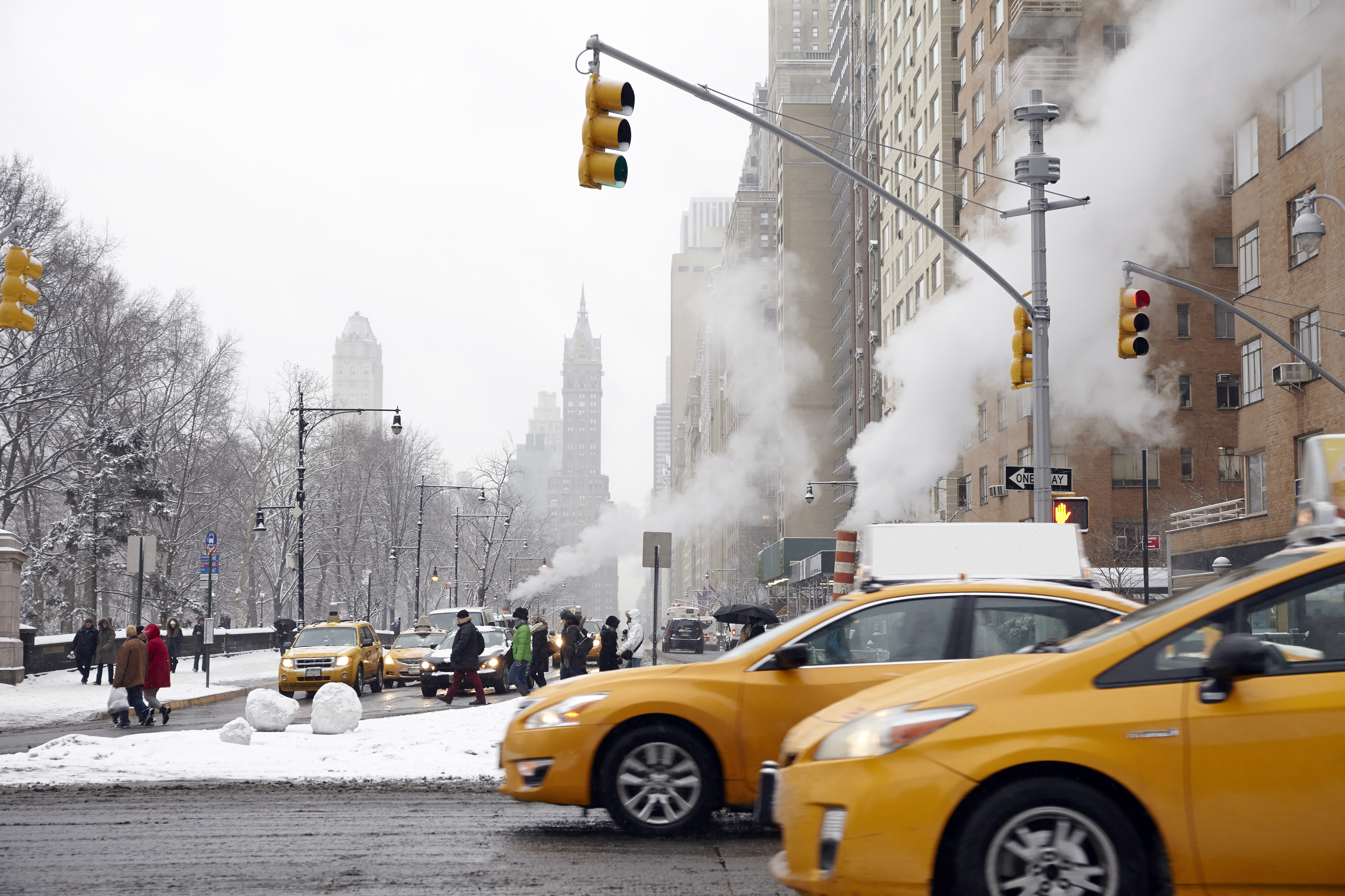
We really shouldn't complain about any weather conditions, given how light a winter it's been so far. But, boy, it will be very difficult not to say something when the frigid air heading toward New York City hits your skin this weekend.
But first, there is a chance our extended snowless streak comes to an end — and it could happen before most people even wake up. It would essentially end on a technicality: A few snow showers could move over the city by 4 a.m., leaving a tenth of an inch or so of snow.
Although unimpressive, it would be just enough to end the long streak, and would be more than Central Park has seen yet this season (which is almost hard to believe). The snow showers will likely be gone before most wake up, and would have minimal impacts on morning commutes.

February starts out chilly, with highs only reaching the upper 30s. It'll warm up a bit Thursday, reaching the 40s, before the arctic plunge arrives. Highs Friday will likely be right around freezing, but will start to quickly tumble from there. Mother Nature turns downright bitter Saturday, with high temps expected in the low-to-mid 20s for the day and mind-numbing wind chills.
Get Tri-state area news delivered to your inbox. Sign up for NBC New York's News Headlines newsletter.
Waking up Saturday, we hope you don't have to be anywhere outside: Expect single-digit lows in the city, and it will feel like -10. It will ne even colder in the Hudson Valley and Connecticut (-17 in Bridgeport, -19 in Poughkeepsie).

If you do have to leave the house, be sure to bundle up: It only takes 30 minutes (or less) for frostbite set in on any exposed skin, and even walking a few blocks to a subway station will feel painful, especially if facing the wind.
There is some good news: The bitter cold won't be here for long. Beginning Saturday afternoon, temperatures will start rising — climbing back up to the much more tolerable low 40s once again by Sunday afternoon. There will be a chance for a bit of rain during the P.M. hours as well.
It will remain fairly pleasant through the early part of next week, as temps will range from the mid 40s to low 50s through Friday, with a chance of showers coming at the end of the workweek. But with temperatures so high, there won't be a concern for snow.
Meanwhile, there won't be a drop of precipitation coming while the temperatures are so bone-chillingly low. In case you somehow haven't noticed, that's something of a trend this winter.
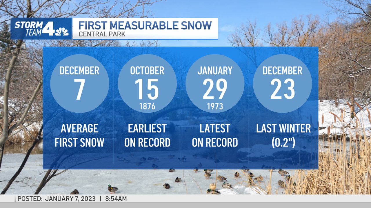
For the first time ever (well, since the Ulysses S. Grant administration, at least), Central Park has not seen measurable snow prior to Jan. 30 of a winter season. The previous latest-ever first measurable snowfall date in the iconic space was Jan. 29, which happened during the winter of 1972-73, according to National Weather Service records.
In a winter that has seen parts of the country walloped by historic snowstorms, including other areas of the Empire State, NYC has been notably bereft of the white stuff. Bereft might be too light a term, considering we haven't seen any measurable snow at all thus far -- and it's about to be February. What else can we break?
If it doesn't snow a measurable amount in NYC overnight into Wednesday, our next records to watch include:
Longest snowless streak ever: As of Monday, we're six days away from eclipsing the No. 1 spot. If we make it to 333 days with no measurable NYC snow that's the longest streak ever -- and it may extend beyond that, too

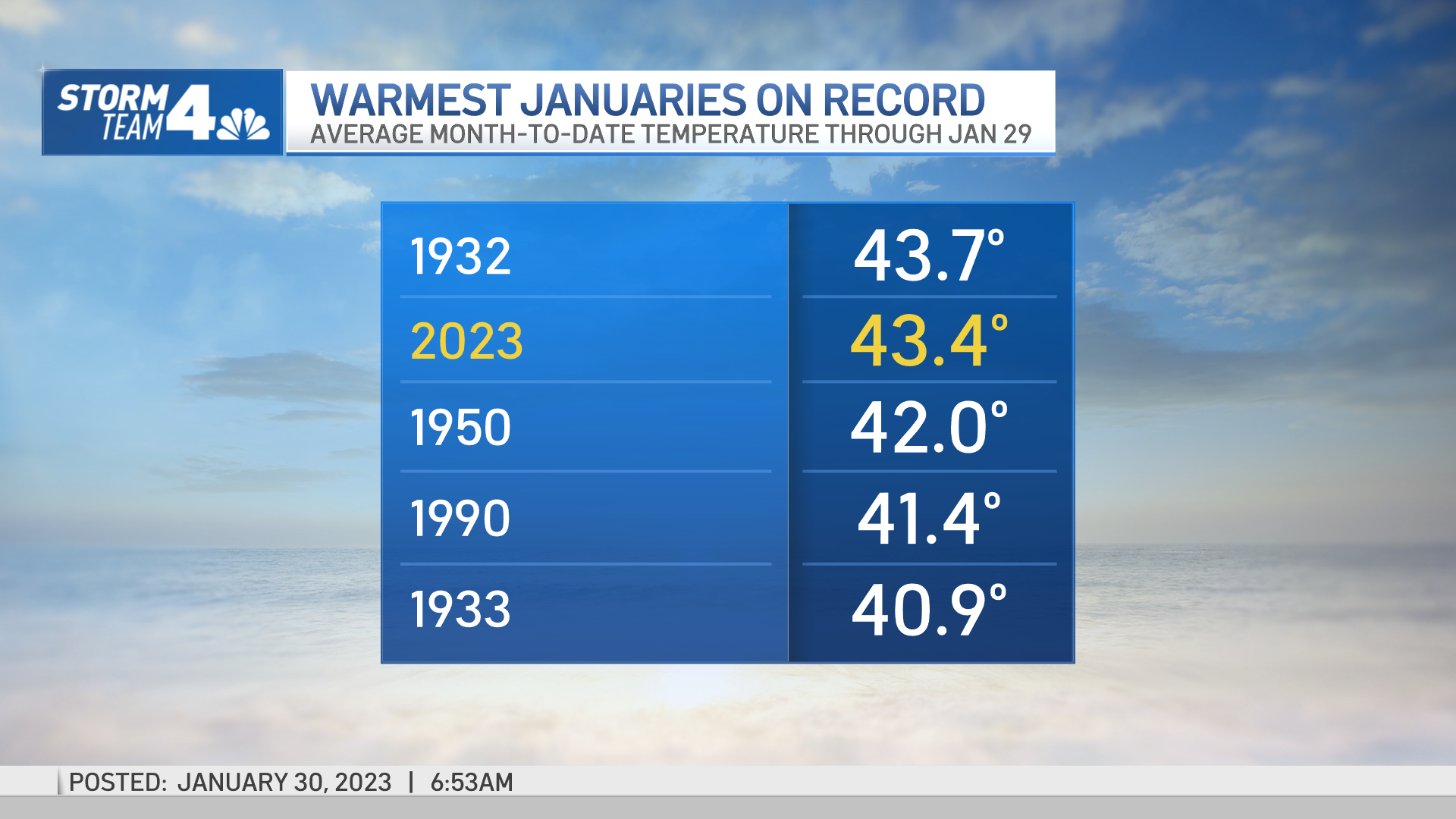
Warmest January ever: New York City made weather history for the second time in 24 hours Tuesday, though unlike a day ago, the five boroughs actually had to do something for this one
January 2023 will go down as the first month NYC has seen above-average temperatures recorded every single day -- the first-ever time the city has accomplished such a feat since record-keeping began in the 1860s. For those who don't love math, that means 31 days in the same month with warmer-than-average temperatures and 0 cooler days.
See more random least snowy NYC winter facts here. Obtenga todos los detalles más recientes en español aquí.
Stay with Storm Team 4 for all the latest updates.
First Central Park Snow Averages
Yes, we've technically seen snowflakes this season, but trace amounts of snow mixed in with rain don't count for weather data recording purposes. (That's not us, that's the National Weather Service.)
Last winter, Central Park recorded its first measurable snowfall on Dec. 23, although it was only 0.2 inches (so, you see, "trace" amounts are really nothing at all). The average first measurable snowfall in the city is Dec. 7, so we're already a month behind the average.

When looking at snowfall totals and temperature records for the region over time, “we’re starting to see in the last 20 years a consistent warming that tells us that there is a climate issue here," New York state climatologist Mark Wysocki said.
He said of the top ten list of lowest snowfall totals measured in Central Park, five of them have been in the 2000s, as have four of the warmest winter temperatures.